Archangelos, Rhodes
Archangelos Αρχάγγελος | |
|---|---|
 | |
 Archangelos Location within the Dodecanese 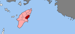 | |
Coordinates: 36°13′N 28°07′E / 36.217°N 28.117°E / 36.217; 28.117Coordinates: 36°13′N 28°07′E / 36.217°N 28.117°E / 36.217; 28.117 | |
| Country | Greece |
| Administrative region | South Aegean |
| Regional unit | Rhodes |
| Municipality | Rhodes |
| • Municipal unit | 115.4 km2 (44.6 sq mi) |
| Elevation | 154 m (505 ft) |
| Population (2011)[1] | |
| • Municipal unit | 7,615 |
| • Municipal unit density | 66/km2 (170/sq mi) |
| Community[1] | |
| • Population | 5,476 (2011) |
| Time zone | UTC+2 (EET) |
| • Summer (DST) | UTC+3 (EEST) |
Archangelos (Greek: Αρχάγγελος) is a town and a former municipality on the island of Rhodes, in the Dodecanese, Greece. Since the 2011 local government reform it is part of the municipality Rhodes, of which it is a municipal unit.[2]
Contents
1 Location and population
2 History
3 Economy
4 Tourist attractions
5 See also
6 References
Location and population
Archangelos is located about 30 kilometers south of the town of Rhodes on the island's east coast at an elevation of 160 meters. Its population according to the 2011 census was 5,384 making it the fifth largest town of the island (after the capital Rhodes, and the town of Trianta (Ialysos), Kremasti and Afantou. The town's name derives from Archangel Michael who is also considered its patron.
The municipal unit of Archangelos has a land area of 115.375 km²,[3] and includes several other towns, the largest of which are Malónas (pop. 982) and Másari (1,004). Its total population was 7,615 at the 2011 census.
History

Ruins of the castle of St.John

The bell tower of Archangel Michael's Orthodox church, the town's patron
Numerous small settlements existed in the broader area of Archangelos during the Hellenistic era, others on the coast and others inland. After the 7th century AD the settlements near the coast were abandoned due to the frequent invasions of pirates and their inhabitants settled on existing inland settlements or founded new ones in more secure areas. Over time the various settlements of the area were merged in one forming the town of Archangelos.
After the fall of Constantinople in 1453, the Knights Hospitaller who were occupying the island of Rhodes since 1309, built a fortress (some sort of an Acropolis) on top of one of the town's nearby hills to protect from a possible Ottoman invasion on the island. Ruins of this (castle of Saint John) fortress remain today.
Economy
Major economic resources include tourism, agriculture (main agricultural products are olive oil and citrus fruits), stockbreeding and pottery. Pottery was always one of the major occupations of the people of Archangelos. It is said that the dome of Hagia Sophia was built using light bricks from Archangelos.
Tourist attractions
In:
- church of the Saint Michael Archangel
Nearby:
- castle of Saint George ruins
- cave of Koumellos
See also
- Haraki
- Stegna, Rhodes
- Tsambika
References
| Wikivoyage has a travel guide for Archangelos. |
| Wikimedia Commons has media related to Archangelos (Rhodes). |
^ ab "Απογραφή Πληθυσμού - Κατοικιών 2011. ΜΟΝΙΜΟΣ Πληθυσμός" (in Greek). Hellenic Statistical Authority..mw-parser-output cite.citation{font-style:inherit}.mw-parser-output q{quotes:"""""""'""'"}.mw-parser-output code.cs1-code{color:inherit;background:inherit;border:inherit;padding:inherit}.mw-parser-output .cs1-lock-free a{background:url("//upload.wikimedia.org/wikipedia/commons/thumb/6/65/Lock-green.svg/9px-Lock-green.svg.png")no-repeat;background-position:right .1em center}.mw-parser-output .cs1-lock-limited a,.mw-parser-output .cs1-lock-registration a{background:url("//upload.wikimedia.org/wikipedia/commons/thumb/d/d6/Lock-gray-alt-2.svg/9px-Lock-gray-alt-2.svg.png")no-repeat;background-position:right .1em center}.mw-parser-output .cs1-lock-subscription a{background:url("//upload.wikimedia.org/wikipedia/commons/thumb/a/aa/Lock-red-alt-2.svg/9px-Lock-red-alt-2.svg.png")no-repeat;background-position:right .1em center}.mw-parser-output .cs1-subscription,.mw-parser-output .cs1-registration{color:#555}.mw-parser-output .cs1-subscription span,.mw-parser-output .cs1-registration span{border-bottom:1px dotted;cursor:help}.mw-parser-output .cs1-hidden-error{display:none;font-size:100%}.mw-parser-output .cs1-visible-error{font-size:100%}.mw-parser-output .cs1-subscription,.mw-parser-output .cs1-registration,.mw-parser-output .cs1-format{font-size:95%}.mw-parser-output .cs1-kern-left,.mw-parser-output .cs1-kern-wl-left{padding-left:0.2em}.mw-parser-output .cs1-kern-right,.mw-parser-output .cs1-kern-wl-right{padding-right:0.2em}
^ Kallikratis law Greece Ministry of Interior (in Greek)
^ "Population & housing census 2001 (incl. area and average elevation)" (PDF) (in Greek). National Statistical Service of Greece. Archived from the original (PDF) on 2015-09-21.


