Unguja
 Unguja | |
 Unguja Location in Tanzania | |
| Geography | |
|---|---|
| Coordinates | 6°08′S 39°20′E / 6.133°S 39.333°E / -6.133; 39.333Coordinates: 6°08′S 39°20′E / 6.133°S 39.333°E / -6.133; 39.333 |
| Archipelago | Zanzibar Archipelago |
| Area | 1,666 km2 (643 sq mi) |
| Length | 85 km (52.8 mi) |
| Width | 30 km (19 mi) |
| Highest elevation | 195 m (640 ft) |
| Highest point | Unnamed point in the Koani chain |
| Administration | |
Tanzania | |
| Region | Zanzibar |
| Demographics | |
| Population | 896,721 (2012) |
Unguja (also referred to as Zanzibar Island or simply Zanzibar, in Ancient Greek Menuthias, Μενουθιάς - as mentioned in The Periplus of the Erythraean Sea) is the largest and most populated island of the Zanzibar archipelago, in Tanzania.
Contents
1 History
2 Geography
3 Politics
4 Population
5 Economy
6 References
7 External links
History
Geography
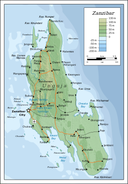
Unguja is a hilly island, about 85 kilometres (53 miles) long (north-south) and 30 kilometres (19 miles) wide (east-west) at its widest, with an overall area of about 1,666 square kilometres (643 square miles).[1] It is located in the southern half of the Zanzibar Archipelago, in the Indian Ocean, about 59 kilometres (37 mi) south of the second largest island of the archipelago, Pemba. Unguja and mainland Tanzania are separated by the Zanzibar Channel.
Unguja is surrounded by a number of smaller islands and islets, with only two of them, Tumbatu and Uzi, being inhabited. Other minor islands around Unguja include Bawe, Chapwani, Changuu, Chumbe, Kizingo, Kwale, Latham, Mautani, Miwi, Mnemba, Mwana wa Mwana, Nianembe, Popo, Pungume, and Ukanga.
Politics
Unguja and the surrounding islands are divided into three regions: Zanzibar Central/South (capital: Koani), Zanzibar North (capital: Mkokotoni), Zanzibar Urban/West (capital: Zanzibar City). Unguja belongs to Zanzibar, which is defined by the Tanzanian Constitution as "a part" of Tanzania with a high degree of autonomy. The local Zanzibari government is based in Stone Town, on the west coast of Unguja.
Population
As of the 2012 census, the total population of Unguja was 896,721, mostly concentrated in the Zanzibar urban region.[2] The main settlement on the island is Zanzibar City, which serves as a capital for Zanzibar and which includes the renowned historical city of Stone Town as well as other populated areas such as Michenzani. Other major settlements on Unguja include Mbweni, Mangapwani, Chwaka, and Nungwi.
People of Unguja mostly speak kiunguja ("the language of Unguja"), which is the dialect of the Swahili language that was used as the main model for the definition of standard Swahili.[3]
Economy

Soap made of seaweed
Unguja is the island of the Zanzibar Archipelago that has the most developed tourism industry. This accounts for a substantial part of Unguja's economy. Agriculture (including the production of spices such as cloves) and fishing are other relevant activities. All along the east coast, most villages also rely on seaweed farming.
References
^ Zanzibar (2007). Zanzibar strategy for growth and reduction of poverty (ZSGRP). Revolutionary Government of Zanzibar. p. 2. Retrieved 15 December 2011..mw-parser-output cite.citation{font-style:inherit}.mw-parser-output .citation q{quotes:"""""""'""'"}.mw-parser-output .citation .cs1-lock-free a{background:url("//upload.wikimedia.org/wikipedia/commons/thumb/6/65/Lock-green.svg/9px-Lock-green.svg.png")no-repeat;background-position:right .1em center}.mw-parser-output .citation .cs1-lock-limited a,.mw-parser-output .citation .cs1-lock-registration a{background:url("//upload.wikimedia.org/wikipedia/commons/thumb/d/d6/Lock-gray-alt-2.svg/9px-Lock-gray-alt-2.svg.png")no-repeat;background-position:right .1em center}.mw-parser-output .citation .cs1-lock-subscription a{background:url("//upload.wikimedia.org/wikipedia/commons/thumb/a/aa/Lock-red-alt-2.svg/9px-Lock-red-alt-2.svg.png")no-repeat;background-position:right .1em center}.mw-parser-output .cs1-subscription,.mw-parser-output .cs1-registration{color:#555}.mw-parser-output .cs1-subscription span,.mw-parser-output .cs1-registration span{border-bottom:1px dotted;cursor:help}.mw-parser-output .cs1-ws-icon a{background:url("//upload.wikimedia.org/wikipedia/commons/thumb/4/4c/Wikisource-logo.svg/12px-Wikisource-logo.svg.png")no-repeat;background-position:right .1em center}.mw-parser-output code.cs1-code{color:inherit;background:inherit;border:inherit;padding:inherit}.mw-parser-output .cs1-hidden-error{display:none;font-size:100%}.mw-parser-output .cs1-visible-error{font-size:100%}.mw-parser-output .cs1-maint{display:none;color:#33aa33;margin-left:0.3em}.mw-parser-output .cs1-subscription,.mw-parser-output .cs1-registration,.mw-parser-output .cs1-format{font-size:95%}.mw-parser-output .cs1-kern-left,.mw-parser-output .cs1-kern-wl-left{padding-left:0.2em}.mw-parser-output .cs1-kern-right,.mw-parser-output .cs1-kern-wl-right{padding-right:0.2em}
^ Population Distribution by Administrative Units, United Republic of Tanzania, 2013, page 2 Archived 2013-05-02 at the Wayback Machine
^ Kiunguja
External links
| Wikimedia Commons has media related to Unguja (Zanzibar Island). |
- Population Growth 1988-2002
- Population Density 2002
Tanzania articles | |||
|---|---|---|---|
| History |
|  | |
| Geography |
| ||
| Politics |
| ||
| Economy |
| ||
| Society |
| ||
| Zanzibar |
| ||
| |||


