Thuringian Highland

Slate houses like these in Gehren characterise many of the villages in the Thuringian Highland
The Thuringian Highland[1]Thuringian Highlands or Thuringian-Vogtlandian Slate Mountains[2] (German: Thüringer Schiefergebirge or Thüringisches Schiefergebirge, literally "Thuringian Slate Hills") is a low range of mountains in the German state of Thuringia.
Contents
1 Geography
2 Geology
3 Rivers and hydro-electric power
4 Mountains and hills
5 See also
6 References
7 Literature
8 External links
Geography
The Thuringian Highland borders on the Thuringian Forest to the southwest. It is plateau about 20 km wide that slopes southeast towards the Saale valley in the area of the Saale Dam and includes parts of the Thuringian Forest and Thuringian Highland and Upper Saale Nature Park.
The largest towns in the Thuringian Highland are Saalfeld and Bad Blankenburg which lie on its northern perimeter, Neuhaus am Rennweg in the highest region and Bad Lobenstein on the eastern edge (where it transitions into Franconian Forest).
The area includes a total of 4 smaller regions:
- upper Saale valley
- Plothen Lake District
- High slate mountains
- Sormitz-Schwarza region
The slate mountains of the Vogtland and Thuringian Highland stretch from the Thuringian Forest to the Ore Mountains (Erzgebirge). They are between about 300 m to 500 m above NN high, and comprise gently rolling hills which are part of the backbone of the Central Uplands. They extend for about 75 km from east to west and 50 km from north to south. Typical features of the landscape are the dolerite peaks or Kuppen (like the Pöhlde or the Hübel) with their wooded crests. These are made from a volcanic rock, dolerite, which is harder than the surrounding rocks and so weathers more slowly, giving rise to the characteristic Kuppen.
Geology
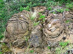
The Steinerne Rose, a diabase rock formation near Saalburg-Ebersdorf
As its German name suggests, the Thuringian Highland is mainly made of slate rock. Although this region was formed in a similar way to the Harz, it lacks the sharp divisions caused by fault lines. Almost all the way round the region transitions gradually into the surrounding land. The rocks found here are from the Palaeozoic era, i.e. the Ordovician, Silurian, Devonian and Lower Carboniferous periods. The most important ones are:
Shale,
Alaunschiefer,
Radiolarite,
Limestone,
Sandstone,
Greywacke,
Dolerite,- Spilite
- and volcanic conglomerates.
Karst-forming, and hence cave-forming, limestone only occurs in a few, small, isolated areas. As a result the number of caves is very low.
Rivers and hydro-electric power
In the Saale Valley there are two of the largest dams in Germany, which form the Hohenwarte and Bleiloch Reservoirs. In the Schwarza Valley there is the Goldisthal Pumped Storage Station, opened in 2003, which is one of the largest pumped-storage hydro-electric power stations in Europe.
Mountains and hills
Around the steep-sided valleys of the Schwarza and Saale the height difference between hilltops and valley bottoms is often as much as 300 m or more, which is large for hills of this size.
Großer Farmdenkopf (869 m), Sonneberg district
Kieferle (867 m), Sonneberg district
Bleßberg (865 m), Hildburghausen district
Dürre Fichte (861 m), Sonneberg district
Breitenberg (Thuringian Forest) (844 m), Sonneberg district- Fellberg (842 m), Steinach, Sonneberg district
Eselsberg (842 m), Hildburghausen district, Thuringian Forest/Thuringian Highland border
Pechleite (839 m), Hildburghausen district
Fehrenberg (835 m), Hildburghausen district, Thuringian Forest/Thuringian Highland border
Hoher Schuß (827 m), Saalfeld-Rudolstadt district
Wurzelberg (820 m), Sonneberg district
Jagdschirm (813 m), Saalfeld-Rudolstadt district
Hintere Haube (811 m), Ilm district
Langer Berg (809 m), Ilm district
Hettstädt (808 m), Saalfeld-Rudolstadt district
Rauhhügel (802 m), Saalfeld-Rudolstadt district
Roter Berg (799 m), Sonneberg district
Wetzstein (791 m), Saalfeld-Rudolstadt district
Meuselbacher Kuppe (786 m), Saalfeld-Rudolstadt district
Fröbelturm (784 m), Saalfeld-Rudolstadt district
Grendel (784 m), Hildburghausen district
Spitzer Berg (781 m), Saalfeld-Rudolstadt district
Simmersberg (781 m), Landkr. Hildburghausen, Thuringian Forest/Thuringian Highland border
Himmelsleiter (Berg) (774 m), Saalfeld-Rudolstadt district
Töpfersbühl (762 m), Saalfeld-Rudolstadt district
Sieglitzberg (733 m), Saale-Orla district
Kirchberg (Thuringia) (725,3 m), Saalfeld-Rudolstadt district
Rosenberg (Thuringian Highland) (716 m), Saalfeld-Rudolstadt district
Großer Mühlberg (714 m), Sonneberg district
Quittelsberg (709 m), Saalfeld-Rudolstadt district
Bocksberg (696 m), Sonneberg district
Auf der Heide (668 m), Saalfeld-Rudolstadt district
Beerberg (667 m), Saalfeld-Rudolstadt district
Barigauer Höhe (665 m), Saalfeld-Rudolstadt district
Zipptanskuppe (657 m), Saalfeld-Rudolstadt district
Rosenbühl (653 m), Saale-Orla district
Keilsburg (648 m), Saalfeld-Rudolstadt district
Eisenberg (636 m), Saalfeld-Rudolstadt district
Talberg (602 m), Saalfeld-Rudolstadt district
Batzenberg (588 m), Saalfeld-Rudolstadt district
Schwarzer Berg (Thuringia) (582 m), Saalfeld-Rudolstadt district
Elmischer Berg (529 m), Saalfeld-Rudolstadt district
Geiersberg (520 m), Saalfeld-Rudolstadt district
Rabenhügel (506 m), Saalfeld-Rudolstadt district
Roderberg (502 m), Saalfeld-Rudolstadt district
Sommerberg (493 m), Saalfeld-Rudolstadt district
Ziegenberg (460 m), Saalfeld-Rudolstadt district
See also
- Thuringian Forest
References
^ Dickinson, Robert E. (1964). Germany: A regional and economic geography (2nd ed.). London: Methuen. p. 629..mw-parser-output cite.citation{font-style:inherit}.mw-parser-output q{quotes:"""""""'""'"}.mw-parser-output code.cs1-code{color:inherit;background:inherit;border:inherit;padding:inherit}.mw-parser-output .cs1-lock-free a{background:url("//upload.wikimedia.org/wikipedia/commons/thumb/6/65/Lock-green.svg/9px-Lock-green.svg.png")no-repeat;background-position:right .1em center}.mw-parser-output .cs1-lock-limited a,.mw-parser-output .cs1-lock-registration a{background:url("//upload.wikimedia.org/wikipedia/commons/thumb/d/d6/Lock-gray-alt-2.svg/9px-Lock-gray-alt-2.svg.png")no-repeat;background-position:right .1em center}.mw-parser-output .cs1-lock-subscription a{background:url("//upload.wikimedia.org/wikipedia/commons/thumb/a/aa/Lock-red-alt-2.svg/9px-Lock-red-alt-2.svg.png")no-repeat;background-position:right .1em center}.mw-parser-output .cs1-subscription,.mw-parser-output .cs1-registration{color:#555}.mw-parser-output .cs1-subscription span,.mw-parser-output .cs1-registration span{border-bottom:1px dotted;cursor:help}.mw-parser-output .cs1-hidden-error{display:none;font-size:100%}.mw-parser-output .cs1-visible-error{font-size:100%}.mw-parser-output .cs1-subscription,.mw-parser-output .cs1-registration,.mw-parser-output .cs1-format{font-size:95%}.mw-parser-output .cs1-kern-left,.mw-parser-output .cs1-kern-wl-left{padding-left:0.2em}.mw-parser-output .cs1-kern-right,.mw-parser-output .cs1-kern-wl-right{padding-right:0.2em}
^ Kohl, Horst; Marcinek, Joachim and Nitz, Bernhard (1986). Geography of the German Democratic Republic, VEB Hermann Haack, Gotha, p. 7 ff.
ISBN 978-3-7301-0522-1.
Literature
- Ernst Kaiser: Thüringerwald und Schiefergebirge, 2. verb. und erg. Aufl., Gotha 1955.
- Adolf Hanle (Hrsg.): Thüringerwald und Schiefergebirge, Mannheim u.a. 1992.
ISBN 3-411-07191-5
External links
- Thuringian Highland Nature Park
Central Uplands of Germany | ||
|---|---|---|
|  | |
Coordinates: 50°30′N 11°10′E / 50.500°N 11.167°E / 50.500; 11.167
Authority control |
|
|---|


