Schoharie Creek
| Schoharie Creek | |
|---|---|
 An autumn view of the Schoharie Creek, facing Northwest from the Schoharie creek bridge | |
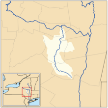 Map of the Schoharie Creek drainage basin | |
| Location | |
| Country | United States |
| State | New York |
| Physical characteristics | |
| Mouth | Mohawk River |
- location | Fort Hunter, New York, United States |
- coordinates | 42°56′28″N 74°17′32″W / 42.94111°N 74.29222°W / 42.94111; -74.29222Coordinates: 42°56′28″N 74°17′32″W / 42.94111°N 74.29222°W / 42.94111; -74.29222 |
- elevation | 274 ft (84 m) |
| Length | 93 mi (150 km) |
| Basin size | 928 sq mi (2,400 km2) |
| Basin features | |
| Tributaries | |
| - left | West Kill, West Kill, Panther Creek, Cobleskill Creek |
| - right | East Kill, Little Schoharie Creek, Fox Creek |

Schoharie Creek near its source in the Catskills
Schoharie Creek in New York, flows north 93 miles (150 km)[1] from the foot of Indian Head Mountain in the Catskills through the Schoharie Valley to the Mohawk River. It is twice impounded north of Prattsville to create New York City's Schoharie Reservoir and the Blenheim-Gilboa Power Project.
During the American Revolutionary War, Iroquois Indian attacks against the cluster of farms in the valley of the Cobleskill Creek tributary was the site of the Cobleskill Massacre (May 1778), virtually depopulating settlements in the southern Mohawk valley. News of this and two other mixed Tory-Indian guerrilla attacks lead to an appropriation of funds for the Sullivan Expedition dispatched by General Washington in 1779 to break the threat of Indian raids.
The Erie Canal crossed over the creek by an aqueduct at Schoharie Crossing State Historic Site.
Two notable bridge collapses have occurred on the Schoharie Creek. In 1987, two spans of the New York State Thruway collapsed. On August 28, 2011, the covered Old Blenheim Bridge collapsed due to flooding from Hurricane Irene.
Contents
1 Tributaries
2 Geography
2.1 Watershed and tributary streams
3 Historic Schoharie
3.1 Old Blenheim Bridge
3.2 New York State Thruway
4 See also
5 References
6 External links
Tributaries
Right
Gooseberry Creek
Red Kill
East Kill
John Chase Brook
Batavia Kill
Hunterfield Creek
Plotter Kill
Keyser Kill
Little Schoharie Creek
Stony Brook
Fox Creek
Bowman Creek
Left
Roaring Kill
Cook Brook
West Kill
Little West Kill
Johnson Hollow Brook
Bear Kill
Mine Kill
West Kill
Cole Brook
Panther Creek
Pleasant Valley Creek
Line Creek
Cobleskill Creek
Cripplebush Creek
Fly Creek
Wilsey Creek
Irish Creek
Geography
Watershed and tributary streams
Schoharie Creek is part of the drainage system of the Hudson River watershed and a direct tributary of the Mohawk River. It has the sister-tributaries: Alplaus Kill, Plotter Kill, North Chuctanunda Creek, South Chuctanunda Creek. These regional streams are tributaries of Schoharie Creek (and its tributaries):
|
|
Historic Schoharie
In the 18th century, areas of the south (or right bank) side of Mohawk Valley were sparsely settled in the face of the periodically warlike and always militant Iroquois peoples, who, while diminished by European diseases during colonial times still retained ample war powers after the French and Indian War ended in 1763. Reorganized by then as the Six Nations the tribes had conducted internecine war with other powerful eastern tribes until the 1770s, weakening or eliminating the power of the Delaware, the Susquehanna, and Shawnee tribes— affecting Amerindian populations and power both East and West of the Alleghenies as far south as northern Kentucky in the west, and southern Maryland in the east. By the end of the French and Indian War, they were the one remaining group of eastern native peoples that retained sufficient military power to give even the British authorities pause. Consequently, those authorities cultivated political arrangements with the Iroquois and as a prelude to the revolution, the British Crown acted to block trans-Appalachian settlements before the opening of the American Revolution, one of the lesser known grievances of many held by the settlers.
During the Revolution, farms in the valley acted as a breadbasket providing important food supplies to the Colonial forces. The lower Mohawk valley was a scene of uneasy native Amerindian–Colonial Settler contention throughout most of the 18th century until after the American Revolutionary War's Sullivan Expedition pacified the region by permanently weakening the Six Nations of the Iroquois. That campaign was a direct result of two atrocities in the region: The May 1778 Battle of Cobleskill (or Cobleskill Creek Massacre) signaled a new guerrilla war offensive by mixed troops of Loyalists and members of the four Iroquois tribes allied to the British in 1778. The incursions resulted in three major raids with major loss of life ranging from Southern New York to Wilkes-Barre, Pennsylvania.
Old Blenheim Bridge
The Old Blenheim Bridge, one of the longest and oldest single-span covered bridges in the world, formerly spanned the creek. The bridge was destroyed on August 28, 2011 by flooding resulting from Hurricane Irene.
New York State Thruway
- Bridge collapses
On the morning of April 5, 1987, after 30 years of service, two spans of the New York State Thruway bridge over the Schoharie Creek near Fort Hunter collapsed. Five vehicles fell into the flooded river, ten of the occupants died.
A subsequent investigation of the collapse determined the cause to be scour.[2][3][4][5]
See also
- List of rivers in New York
References
^ "The National Map". U.S. Geological Survey. Retrieved Feb 11, 2011..mw-parser-output cite.citation{font-style:inherit}.mw-parser-output .citation q{quotes:"""""""'""'"}.mw-parser-output .citation .cs1-lock-free a{background:url("//upload.wikimedia.org/wikipedia/commons/thumb/6/65/Lock-green.svg/9px-Lock-green.svg.png")no-repeat;background-position:right .1em center}.mw-parser-output .citation .cs1-lock-limited a,.mw-parser-output .citation .cs1-lock-registration a{background:url("//upload.wikimedia.org/wikipedia/commons/thumb/d/d6/Lock-gray-alt-2.svg/9px-Lock-gray-alt-2.svg.png")no-repeat;background-position:right .1em center}.mw-parser-output .citation .cs1-lock-subscription a{background:url("//upload.wikimedia.org/wikipedia/commons/thumb/a/aa/Lock-red-alt-2.svg/9px-Lock-red-alt-2.svg.png")no-repeat;background-position:right .1em center}.mw-parser-output .cs1-subscription,.mw-parser-output .cs1-registration{color:#555}.mw-parser-output .cs1-subscription span,.mw-parser-output .cs1-registration span{border-bottom:1px dotted;cursor:help}.mw-parser-output .cs1-ws-icon a{background:url("//upload.wikimedia.org/wikipedia/commons/thumb/4/4c/Wikisource-logo.svg/12px-Wikisource-logo.svg.png")no-repeat;background-position:right .1em center}.mw-parser-output code.cs1-code{color:inherit;background:inherit;border:inherit;padding:inherit}.mw-parser-output .cs1-hidden-error{display:none;font-size:100%}.mw-parser-output .cs1-visible-error{font-size:100%}.mw-parser-output .cs1-maint{display:none;color:#33aa33;margin-left:0.3em}.mw-parser-output .cs1-subscription,.mw-parser-output .cs1-registration,.mw-parser-output .cs1-format{font-size:95%}.mw-parser-output .cs1-kern-left,.mw-parser-output .cs1-kern-wl-left{padding-left:0.2em}.mw-parser-output .cs1-kern-right,.mw-parser-output .cs1-kern-wl-right{padding-right:0.2em}
^ "Lessons from the Collapse of the Schoharie Creek Bridge". Cedb.asce.org. 1987-04-05. Retrieved 2011-09-01.
^ http://www.pubs.asce.org/WWWdisplay.cgi?0700417
^ Boorstin, Robert O. (July 1, 1987). "Floodwaters Called Cause Of Bridge Collapse". The New York Times.
^ "Lessons from the Collapse of the Schoharie Creek Bridge". Eng.uab.edu. Archived from the original on 2006-10-07. Retrieved 2011-09-01.
External links
- The Collapse of the Schoharie Creek Bridge
Hudson River watershed | |
|---|---|
| Tributaries |
|
| Lakes |
|
| Towns |
|
| Landmarks |
|


