Santiam River
| Santiam River | |
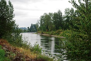 Near Interstate 5 in Linn County | |
Name origin: Kalapuya tribe that lived near the river until removal to the Grande Ronde Reservation[1] | |
| Country | United States |
|---|---|
| State | Oregon |
| County | Linn and Marion |
| Source | confluence of North Santiam and South Santiam rivers |
| - location | Linn and Marion counties, Oregon |
| - elevation | 222 ft (68 m) [4] |
| - coordinates | 44°41′21″N 123°00′27″W / 44.68917°N 123.00750°W / 44.68917; -123.00750 [3] |
| Mouth | Willamette River |
| - location | between Albany and Salem, Marion County, Willamette Valley, Oregon |
| - elevation | 164 ft (50 m) [3] |
| - coordinates | 44°45′00″N 123°08′20″W / 44.75000°N 123.13889°W / 44.75000; -123.13889Coordinates: 44°45′00″N 123°08′20″W / 44.75000°N 123.13889°W / 44.75000; -123.13889 [3] |
| Length | 12 mi (19 km) [2] |
| Basin | 1,830 sq mi (4,740 km2) |
| Discharge | for Jefferson |
| - average | 7,714 cu ft/s (218 m3/s) |
| - max | 202,000 cu ft/s (5,720 m3/s) |
| - min | 260 cu ft/s (7 m3/s) |
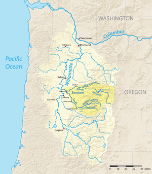 Map of the Willamette River watershed with the Santiam River highlighted | |
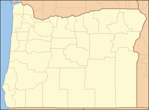 Location of the mouth of the Santiam River in Oregon | |
The Santiam River /ˌsæntiːˈæm/ is a tributary of the Willamette River, about 12 miles (19 km) long, in western Oregon in the United States. Through its two principal tributaries, the North Santiam and the South Santiam rivers, it drains a large area of the Cascade Range at the eastern side of the Willamette Valley east of Salem and Corvallis.
The main course of the river is short, formed in the Willamette Valley by the confluence of the North and South Santiam rivers on the border between Linn and Marion counties approximately 8 miles (13 km) northeast of Albany. It flows generally west-northwest in a slow meandering course to join the Willamette from the east approximately 8 miles (13 km) north of Albany.
Both the North and South Santiam rise in high Cascades in eastern Linn County. The Middle Santiam River joins the South Santiam where the South Santiam is impounded to form Foster Lake. The North Santiam is impounded to form the 400-foot (120 m) deep Detroit Lake in the Cascades. The Santiam is a major source of water supply for Salem.
The Great Willamette Flood of 1861, which crested on December 2, destroyed a large number of structures and animals on prairies near its confluence with the Willamette River and south of Knox Butte.[5]
Santiam River Zone is staffed by the Santiam Type 2 initial attack hand crew and two engines based out of the Detroit Ranger District. Additionally the Willamette National Forest has fire crews on the Mckenzie and Middle Fork Ranger Districts.
See also
- List of Oregon rivers
- Willamette Riverkeeper
References
^ McArthur, Lewis A.; McArthur, Lewis L. (2003). Oregon Geographic Names (Seventh ed.). Portland, Oregon: Oregon Historical Society Press. p. 848. ISBN 0-87595-277-1..mw-parser-output cite.citation{font-style:inherit}.mw-parser-output q{quotes:"""""""'""'"}.mw-parser-output code.cs1-code{color:inherit;background:inherit;border:inherit;padding:inherit}.mw-parser-output .cs1-lock-free a{background:url("//upload.wikimedia.org/wikipedia/commons/thumb/6/65/Lock-green.svg/9px-Lock-green.svg.png")no-repeat;background-position:right .1em center}.mw-parser-output .cs1-lock-limited a,.mw-parser-output .cs1-lock-registration a{background:url("//upload.wikimedia.org/wikipedia/commons/thumb/d/d6/Lock-gray-alt-2.svg/9px-Lock-gray-alt-2.svg.png")no-repeat;background-position:right .1em center}.mw-parser-output .cs1-lock-subscription a{background:url("//upload.wikimedia.org/wikipedia/commons/thumb/a/aa/Lock-red-alt-2.svg/9px-Lock-red-alt-2.svg.png")no-repeat;background-position:right .1em center}.mw-parser-output .cs1-subscription,.mw-parser-output .cs1-registration{color:#555}.mw-parser-output .cs1-subscription span,.mw-parser-output .cs1-registration span{border-bottom:1px dotted;cursor:help}.mw-parser-output .cs1-hidden-error{display:none;font-size:100%}.mw-parser-output .cs1-visible-error{font-size:100%}.mw-parser-output .cs1-subscription,.mw-parser-output .cs1-registration,.mw-parser-output .cs1-format{font-size:95%}.mw-parser-output .cs1-kern-left,.mw-parser-output .cs1-kern-wl-left{padding-left:0.2em}.mw-parser-output .cs1-kern-right,.mw-parser-output .cs1-kern-wl-right{padding-right:0.2em}
^ United States Geological Survey. "United States Geological Survey Topographic Map". TopoQuest. Retrieved July 24, 2009. The maps, which include river mile (RM) markers for the river's entire length, depict the following Oregon quadrants from mouth to source: Monmouth, Sydney, and Albany.
^ abc "Santiam River". Geographic Names Information System (GNIS). United States Geological Survey. November 28, 1980. Retrieved July 24, 2009.
^ Google Earth elevation for GNIS coordinates
^ Stephenie Flora. "Marion County Flood of 1861". The Oregon Territory and Its Pioneers. Retrieved November 22, 2007.
External links
- North Santiam Watershed Council
- South Santiam Watershed Council
- Willamette Riverkeeper


