Yuba River
| Yuba River Henneet[1], Rio De Los Yubas[1] | |
|---|---|
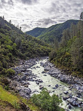 At South Yuba River State Park | |
 Map of the Yuba River basin | |
| Etymology | From the name of a Maidu village |
| Location | |
| Country | United States |
| State | California |
| Region | Nevada County |
| Cities | North San Juan, Marysville, Yuba City |
| Physical characteristics | |
| Source | Confluence of North and Middle Yuba River |
| - location | Near North San Juan, Yuba/Nevada county line |
| - coordinates | 39°22′07″N 121°08′11″W / 39.36861°N 121.13639°W / 39.36861; -121.13639 |
| - elevation | 1,129 ft (344 m) |
| Mouth | Feather River |
- location | Yuba City-Marysville, Yuba County |
- coordinates | 39°07′39″N 121°35′48″W / 39.12750°N 121.59667°W / 39.12750; -121.59667Coordinates: 39°07′39″N 121°35′48″W / 39.12750°N 121.59667°W / 39.12750; -121.59667 |
- elevation | 49 ft (15 m) |
| Length | 39.7 mi (63.9 km)[2] |
| Basin size | 1,345 sq mi (3,480 km2)[2] |
| Discharge | |
| - location | near Marysville, about 4.2 mi (6.8 km) from the mouth[3] |
| - average | 2,334 cu ft/s (66.1 m3/s)[3] |
| - minimum | 15 cu ft/s (0.42 m3/s) |
| - maximum | 180,000 cu ft/s (5,100 m3/s) |
| Basin features | |
| River system | Feather River basin |
| Tributaries | |
| - left | Middle Yuba River, South Yuba River, Deer Creek (Nevada County, California) |
| - right | North Yuba River |
The Yuba River is a tributary of the Feather River in the Sierra Nevada and eastern Sacramento Valley, in the U.S. state of California. The main stem of the river is about 40 miles (64 km) long,[2] and its headwaters are split into three major forks. The Yuba River proper is formed at the confluence of the North Yuba and Middle Yuba Rivers, with the South Yuba joining a short distance downstream. Measured to the head of the North Yuba River, the Yuba River is just over 100 miles (160 km) long.
The river drains 1,345 square miles (3,480 km2)[2], mostly in the western slope and foothills of the Sierra Nevada. The average runoff of the Yuba River basin is approximately 2,303,000 acre feet (2.841 km3) per year,[4] providing about one-third of the flow of the Feather River, and 10 percent of the flow of the Sacramento River, which the Feather ultimately drains into. Since the early 20th century, the river's flow has been gradually reduced by irrigation and hydropower diversion projects.
The river's name comes from a Maidu village, spelled in early records as Yubu and applied to the river by 1844.[5] Some claim the name is a variant of Spanish uba or uva, referring to grapes found growing along the banks of the river.[6]
Contents
1 Course
1.1 North Yuba River
1.2 Middle Yuba River
1.3 South Yuba River
1.4 Main stem
2 History
3 Dams and diversions
4 Environmental issues
5 Tributaries
6 See also
7 Gallery
8 References
Course
North Yuba River
The North Yuba River, 61.1 miles (98.3 km) long,[2] rises near the eastern boundary of the Tahoe National Forest, at Yuba Pass along California State Route 49. It flows southwest then west through a 3,000-foot-deep (910 m) canyon past the villages of Downieville (where it receives the Downie River from the north) and Goodyears Bar. After receiving Canyon Creek and Slate Creek, its main tributaries, it flows into the 4,800-acre (1,900 ha) New Bullards Bar Reservoir, impounded by the 645-foot (197 m) New Bullards Bar Dam. About 5 miles (8.0 km) below New Bullards Bar Dam, it joins with the Middle Yuba River to form the Yuba River.[7]
Middle Yuba River
Originating in a bowl-shaped valley in Moscove Meadow, the 55.4-mile-long (89.2 km) Middle Yuba River[2] flows north into Jackson Meadows Reservoir, then turns west, descending steeply into a gorge, defining over almost its entire length the boundary of Sierra County in the north and Nevada County in the south. The river bends to the southwest, then west again, receiving Kanaka Creek from the right and Grizzly Creek from the left. It intersects California State Route 49 about 2 miles (3.2 km) northwest of North San Juan, then a few miles after joins with the North Yuba River.[7]
South Yuba River
The 65.3-mile-long (105.1 km) [2] South Yuba River originates at Lake Angela in Nevada County about three quarters of a mile north of Donner Pass, about three miles east of the town of Soda Springs. After passing through Lake Van Norden with Upper Castle Creek (longer than the Lake Angela stem) entering from the right, it gathers numerous snow-fed tributaries running west through a marshy, lake-filled valley, criss-crossing Interstate 80. The river briefly enters Placer County, then flows into Lake Spaulding, then plunges westward into a gorge. Canyon Creek enters from the right, then Poorman Creek also from the right near the town of Washington. The river continues west into the foothills, crossing under State Route 49. Its mouth is on the east shore of upper Englebright Lake, formed by a dam across the Yuba River.[7]
|
Main stem

Satellite view of the lower Yuba River -- Yuba City/Marysville and the Feather River lie near the bottom left; Yuba Goldfields are in the upper right center
From the joining of the three rivers; North Yuba River and Middle Yuba River, it flows southwards, then southwest, through the Sierra Nevada foothills, forming the Yuba-Nevada County border. The river widens into the main arm of Englebright Lake near French Bar, and is joined by the South Yuba within the reservoir. The Yuba leaves the Englebright Dam near Lake Wildwood, California and is then joined by Deer Creek, the stream flowing from that lake, on the left. The Yuba slows down as it flows from the mountains out into the Sacramento Valley near the Yuba Goldfields, a section of the Yuba River valley consisting of dredged sediments washed down by hydraulic mining in the 19th century. The river then turns southwest, flowing through irrigated farmland. It then skirts the south side of Marysville and reaches its destination at the Feather River between the cities of Marysville, Yuba City and Linda.[7]
History

Large gold nugget from the Yuba River placers, weight 182 g.
The Yuba River valley was originally one of the most densely populated Native American areas in California. Historians divide indigenous peoples living in the Yuba River area into several groups – the Konkow, Maidu, Nisenan and Miwok.[8][9] These groups did not function as large tribes; rather, they were divided into hundreds of small villages, with distinct governments but similar customs. Like other indigenous people of the Sierra Nevada foothill region, their staple food were acorns, but they also hunted and gathered for other foods including abundant salmon runs in the Yuba River.[10]
In the 1850s, the California Gold Rush brought large numbers of European-American settlers into the area, followed by many Mexican, African and Chinese immigrants. These settlers brought diseases with them, to which the Native Americans had no immunity. Within a few years, these diseases wiped out most of the native population. The Yuba River and its forks were one of the richest parts of the Mother Lode, and miners poured to the region in great numbers.[11] Although gold was first extracted by simple methods such as panning and sluicing, large-scale industrial hydraulic mining left a much greater impact. About 25 million cubic yards (19,400,000 m3) of hydraulic mining debris was carried down the Yuba River. This raised stream beds up to 50 ft (15 m) in places, buried riverside land under sediment, and increased the risk of flooding.[12] The practice was banned in 1884 following lawsuits from farmers who had been affected by the debris flows.
Much of the debris left by the destruction of hydraulic mining remains today as the Yuba Goldfields.[13][14] In addition, the extensive use of mercury in processing gold led to a contamination of a relative large area. In 2013 the contamination was still detectable and will be so for an estimated time of more than 10,000 years.[15]
In 1877, the world's first long-distance telephone line was strung along the South Yuba River from French Corral to French Lake (now called Bowman Lake), a distance of 58 miles (93 km).[16]
Dams and diversions

Yuba River at Parks Bar, 1991
Like the majority of California rivers, the Yuba was dammed at many points during the 20th century, and large amounts of water are withdrawn for irrigation and municipal water supply. Daguerre Point Dam was built in 1906 by the U.S. Army Corps of Engineers in order to trap hydraulic mining debris. After concerns about its impact on fish populations, the dam was fitted with fish ladders in 1937.[17] In 1922-24 PG&E built the original Bullards Bar Dam to produce hydroelectricity and trap debris. The concrete arch Englebright Dam was built in 1941 to trap mining debris following the re-legalization of hydraulic mining during the 1930s. However, mining never resumed on a Gold Rush scale in the Yuba River watershed. Today, Englebright serves mainly to produce hydroelectricity.[18]
New Bullards Bar Dam was built on the North Yuba River in response to the huge flood of December 1955,[19] which destroyed much of Yuba City.[20] Completed in 1969, the 645 ft (197 m) high concrete arch dam is one of the tallest dams in the United States, replacing and submerging the old Bullards Bar Dam. It stores almost 1 million acre feet (1.2 km3) to provide flood control, irrigation and hydroelectricity.[21]
The Yuba River Development Project includes New Bullards Bar Dam and a number of supporting facilities, including a diversion dam (Our House Dam) and tunnel which divert the Middle Yuba River into New Bullards Bar Reservoir, to increase hydropower generation. The 340 megawatt New Colgate Powerhouse is located about 4 miles (6.4 km) below New Bullards Bar Dam, and it generates over 1.3 billion kilowatt hours of energy per year.[22][23] These diversions have resulted in the seasonal dewatering of the lower North Yuba River and Middle Yuba River and about four miles of the main Yuba River.
The Middle Yuba River and South Yuba River are linked by the Yuba-Bear and Drum-Spaulding hydroelectric projects, which are owned by the Nevada Irrigation District and PG&E, respectively. These two interconnected projects generate a combined 1.2 billion kilowatt hours per year[24] and with over 40 dams and reservoirs and 16 powerhouses, are considered the most complex hydroelectric scheme in the United States.[25] Major dams include Jackson Meadows Dam and Bowman Dam (part of Yuba-Bear) and Lake Spaulding Dam and Fordyce Lake Dam (part of Drum-Spaulding). These projects divert a portion of the Yuba River's flow to the Bear River, a tributary of the Feather River further south.
Other dams include Scotts Flat and Wildwood on Deer Creek; and Mildred and Virginia Ranch on Dry Creek, a lower tributary of the Yuba.
Environmental issues
The California Office of Environmental Health Hazard Assessment has issued a safe eating advisory for any fish caught in Yuba River, North Yuba River, and Middle Yuba River due to elevated levels of mercury.[26]
Tributaries
In hierarchical order, going upstream:
|
|
See also
- List of rivers of California
| Wikimedia Commons has media related to Yuba River. |
Gallery
.mw-parser-output .mod-gallery{display:table}.mw-parser-output .mod-gallery-default{background:transparent;margin-top:0.5em}.mw-parser-output .mod-gallery-center{margin-left:auto;margin-right:auto}.mw-parser-output .mod-gallery-left{float:left}.mw-parser-output .mod-gallery-right{float:right}.mw-parser-output .mod-gallery-none{float:none}.mw-parser-output .mod-gallery-collapsible{width:100%}.mw-parser-output .mod-gallery .title{display:table-row}.mw-parser-output .mod-gallery .title>div{display:table-cell;text-align:center;font-weight:bold}.mw-parser-output .mod-gallery .main{display:table-row}.mw-parser-output .mod-gallery .main>div{display:table-cell}.mw-parser-output .mod-gallery .caption{display:table-row;vertical-align:top}.mw-parser-output .mod-gallery .caption>div{display:table-cell;display:block;font-size:94%;padding:0}.mw-parser-output .mod-gallery .footer{display:table-row}.mw-parser-output .mod-gallery .footer>div{display:table-cell;text-align:right;font-size:80%;line-height:1em}.mw-parser-output .mod-gallery .gallerybox .thumb img{background:none}.mw-parser-output .mod-gallery .bordered-images img{border:solid #eee 1px}.mw-parser-output .mod-gallery .whitebg img{background:#fff!important}.mw-parser-output .mod-gallery .gallerybox div{background:#fff!important}

A view of the South Fork of the Yuba River from the North Bloomfield Road bridge

A waterfall on the South Fork Yuba River in South Yuba River State Park

The Bridgeport covered bridge on the South Fork Yuba River in South Yuba River State Park

The South Fork of the Yuba River as it intersects with State Highway 49

USGS map of the Yuba River watershed


References
^ ab "Yuba River". Geographic Names Information System. United States Geological Survey. 1981-01-19. Retrieved 2010-08-23..mw-parser-output cite.citation{font-style:inherit}.mw-parser-output .citation q{quotes:"""""""'""'"}.mw-parser-output .citation .cs1-lock-free a{background:url("//upload.wikimedia.org/wikipedia/commons/thumb/6/65/Lock-green.svg/9px-Lock-green.svg.png")no-repeat;background-position:right .1em center}.mw-parser-output .citation .cs1-lock-limited a,.mw-parser-output .citation .cs1-lock-registration a{background:url("//upload.wikimedia.org/wikipedia/commons/thumb/d/d6/Lock-gray-alt-2.svg/9px-Lock-gray-alt-2.svg.png")no-repeat;background-position:right .1em center}.mw-parser-output .citation .cs1-lock-subscription a{background:url("//upload.wikimedia.org/wikipedia/commons/thumb/a/aa/Lock-red-alt-2.svg/9px-Lock-red-alt-2.svg.png")no-repeat;background-position:right .1em center}.mw-parser-output .cs1-subscription,.mw-parser-output .cs1-registration{color:#555}.mw-parser-output .cs1-subscription span,.mw-parser-output .cs1-registration span{border-bottom:1px dotted;cursor:help}.mw-parser-output .cs1-ws-icon a{background:url("//upload.wikimedia.org/wikipedia/commons/thumb/4/4c/Wikisource-logo.svg/12px-Wikisource-logo.svg.png")no-repeat;background-position:right .1em center}.mw-parser-output code.cs1-code{color:inherit;background:inherit;border:inherit;padding:inherit}.mw-parser-output .cs1-hidden-error{display:none;font-size:100%}.mw-parser-output .cs1-visible-error{font-size:100%}.mw-parser-output .cs1-maint{display:none;color:#33aa33;margin-left:0.3em}.mw-parser-output .cs1-subscription,.mw-parser-output .cs1-registration,.mw-parser-output .cs1-format{font-size:95%}.mw-parser-output .cs1-kern-left,.mw-parser-output .cs1-kern-wl-left{padding-left:0.2em}.mw-parser-output .cs1-kern-right,.mw-parser-output .cs1-kern-wl-right{padding-right:0.2em}
^ abcdefg U.S. Geological Survey. National Hydrography Dataset high-resolution flowline data. The National Map, accessed March 10, 2011
^ ab "USGS Gage #11421000 on the Yuba River near Marysville, CA: Water-Data Report 2013" (PDF). National Water Information System. United States Geological Survey. 2013. Retrieved 2017-04-14.
^ "California Central Valley Unimpaired Flow Data, Fourth Edition" (PDF). California State Water Resources Control Board. May 2007. Retrieved 2017-04-14.
^ Bright, William (1998). 1500 California Place Names: Their Origin and Meaning. University of California Press. p. 168. ISBN 978-0-520-21271-8.
^ Yuba City budget
^ abcd USGS Topo Maps for United States (Map). Cartography by United States Geological Survey. ACME Mapper. Retrieved 2010-08-23.
^ "California Native Americans Map". San Manuel Band of Mission Indians. Retrieved 2010-08-08.
^ "California Indian Tribal Groups". California Indian Library Collections. Retrieved 2010-08-08.
^ Hanson, George Emmanuel (2007). "Native Races of Yuba River Valley". The Early History of the Yuba River Valley. Yuba County History. Retrieved 2010-08-24.
^ "Cultural History of the South Yuba River Canyon". South Yuba River State Park. Nevada County Gold. Retrieved 2010-08-25.
^ Garvin, Cosmo (2002-10-24). "This land ain't your land: Much of the Yuba Goldfields are supposed to be public property, but the mining industry is treating the moon-like landscape as personal property. That's not sitting well with the locals". newsreview.com. Retrieved 2010-08-25.
^ "Yuba Goldfields, California". NASA Earth Observatory. National Aeronautics and Space Administration. 2005-05-24. Retrieved 2010-08-25.
^ Baumgart, Don. "Pressure Builds to End Hydraulic Gold Mining". California Gold Rush History. Nevada County Gold. Retrieved 2010-08-25.
^ Singer, M. B.; Aalto, R.; James, L. A.; Kilham, N. E.; Higson, J. L.; Ghoshal, S. (2013). "Enduring legacy of a toxic fan via episodic redistribution of California gold mining debris". Proceedings of the National Academy of Sciences. 110: 18436–18441. doi:10.1073/pnas.1302295110. PMC 3831998. PMID 24167273.
^ "CHL No. 247 First Long-Distance Telephone Line". California Historical Landmarks. Retrieved 2017-10-16.
^ http://www.water.ca.gov/fishpassage/projects/daguerre.cfm
^ Childs, Jonathan R.; Snyder, Noah P.; Hampton, Margaret A. (2003). "Bathymetric and geophysical surveys of Englebright Lake, Yuba-Nevada Counties, California". Western Coastal & Marine Geology. U.S. Geological Survey. Retrieved 2010-08-25.
^ "History of Flooding and Flood Control". Be Prepared Yuba. 2012. Retrieved 2017-10-16.
^ "Flood Aware" (PDF). Sutter Butte Flood Control Agency. 2010-10-31. Retrieved 2017-10-16.
^ "New Bullards Bar Dam and Reservoir". Northern California Water Association. Retrieved 2010-08-25.
^ http://www.ycwa-relicensing.com/Relicensing%20Documents/Relicensing%20Documents%2001%20-%20Preliminary%20Information%20Package/3_0%20-%20General%20Description%20of%20River%20Basin.pdf
^ http://www.ycwa-relicensing.com/default.aspx
^ http://www.foothillswaternetwork.org/relicensing/index.php
^ http://www.hdrinc.com/portfolio/yuba-bear-and-drum-spaulding-hydroelectric-project-relicensings
^ Admin, OEHHA (2018-09-13). "Yuba River, North Yuba River, and Middle Yuba River". OEHHA. Retrieved 2018-11-13.
| Wikimedia Commons has media related to Yuba River. |


