Nišava District
Nišava District Нишавски округ Nišavski okrug | |
|---|---|
District of Serbia | |
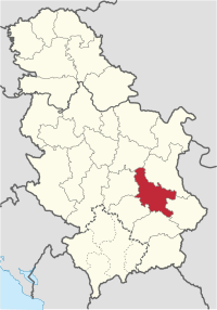 Location of the Nišava District within Serbia | |
| Country | |
| Region | Southern and Eastern Serbia |
| Administrative center | Niš |
| Government | |
| • Commissioner | Dragana Sotirovski |
| Area | |
| • Total | 2,729 km2 (1,054 sq mi) |
| Population (2011)[citation needed] | |
| • Total | 372,404 (est. 524,500) |
| • Density | 136.8/km2 (354/sq mi) |
| ISO 3166 code | RS-20 |
| Municipalities | 6 and 1 city |
| Settlements | 285 |
| - Cities and towns | 8 |
| - Villages | 277 |
| Website | www.nis.okrug.gov.rs |
The Nišava District (Serbian: Нишавски округ / Nišavski okrug, pronounced [nîʃaʋskiː ôkruːɡ]) is one of nine administrative districts of Southern and Eastern Serbia. It expands to the south-eastern parts of Serbia. According to the 2011 census results, it has a population of 372,404 inhabitants. The administrative center of the district is the city of Niš.
Contents
1 Municipalities
2 Demographics
2.1 Ethnic groups
3 Tourism
4 Economy
5 See also
6 References
7 External links
Municipalities
The district is divided into 6 municipalities and the city of Niš, which is divided into 5 municipalities.
The municipalities of the district are:
- Aleksinac
- Svrljig
- Merošina
- Ražanj
- Doljevac
- Gadžin Han
City of Niš is divided into municipalities of:
- Medijana
- Niška Banja
- Palilula
- Pantelej
- Crveni Krst
Demographics
| Historical population | ||
|---|---|---|
| Year | Pop. | ±% p.a. |
| 1948 | 283,842 | — |
| 1953 | 303,482 | +1.35% |
| 1961 | 327,367 | +0.95% |
| 1971 | 363,292 | +1.05% |
| 1981 | 394,110 | +0.82% |
| 1991 | 396,043 | +0.05% |
| 2002 | 381,757 | −0.33% |
| 2011 | 376,319 | −0.16% |
| Source: [1] | ||
According to the last official census done in 2011, the Nišava District has 376,319 inhabitants. Census doesn’t include refugees. It’s estimated that there are up to 524,500 people living in Nišava District.[citation needed]
Ethnic groups
Serbs = 351,676
Romani = 11,499- others
Tourism
Within the city boundaries itself stands the Niš Fortress, which ranks among the most beautiful and best preserved fortresses in the Balkans, built in the late seventeenth century. On the outskirts of Niš is a unique monument - the Skull Tower (Ćele kula) built by the Turks from the skulls and heads of the Serbian warriors who died in the Battle of Čegar in 1809, led by Stevan Sinđelić, against the Turks. After the Turkish victory, this battle was decisive for the failure of the First Serb Uprising.
The Nišava District also features Niška Banja, it is one of the best known spa tourism centers in Serbia. It is located on the bottom of Suva Planina and a few kilometers away from Niš.
Economy
The economy of this region is dominated by: the Elektronska Industrija Niš, tobacco industry, Mašinska Industrija Niš and the Niteks textile industry.
See also
- Administrative divisions of Serbia
- Districts of Serbia
References
^ "2011 Census of Population, Households and Dwellings in the Republic of Serbia" (PDF). stat.gov.rs. Statistical Office of the Republic of Serbia. Retrieved 11 January 2017..mw-parser-output cite.citation{font-style:inherit}.mw-parser-output .citation q{quotes:"""""""'""'"}.mw-parser-output .citation .cs1-lock-free a{background:url("//upload.wikimedia.org/wikipedia/commons/thumb/6/65/Lock-green.svg/9px-Lock-green.svg.png")no-repeat;background-position:right .1em center}.mw-parser-output .citation .cs1-lock-limited a,.mw-parser-output .citation .cs1-lock-registration a{background:url("//upload.wikimedia.org/wikipedia/commons/thumb/d/d6/Lock-gray-alt-2.svg/9px-Lock-gray-alt-2.svg.png")no-repeat;background-position:right .1em center}.mw-parser-output .citation .cs1-lock-subscription a{background:url("//upload.wikimedia.org/wikipedia/commons/thumb/a/aa/Lock-red-alt-2.svg/9px-Lock-red-alt-2.svg.png")no-repeat;background-position:right .1em center}.mw-parser-output .cs1-subscription,.mw-parser-output .cs1-registration{color:#555}.mw-parser-output .cs1-subscription span,.mw-parser-output .cs1-registration span{border-bottom:1px dotted;cursor:help}.mw-parser-output .cs1-ws-icon a{background:url("//upload.wikimedia.org/wikipedia/commons/thumb/4/4c/Wikisource-logo.svg/12px-Wikisource-logo.svg.png")no-repeat;background-position:right .1em center}.mw-parser-output code.cs1-code{color:inherit;background:inherit;border:inherit;padding:inherit}.mw-parser-output .cs1-hidden-error{display:none;font-size:100%}.mw-parser-output .cs1-visible-error{font-size:100%}.mw-parser-output .cs1-maint{display:none;color:#33aa33;margin-left:0.3em}.mw-parser-output .cs1-subscription,.mw-parser-output .cs1-registration,.mw-parser-output .cs1-format{font-size:95%}.mw-parser-output .cs1-kern-left,.mw-parser-output .cs1-kern-wl-left{padding-left:0.2em}.mw-parser-output .cs1-kern-right,.mw-parser-output .cs1-kern-wl-right{padding-right:0.2em}
Note: All official material made by the Government of Serbia is public by law. Information was taken from web.archive.org/web/20090221052324/http://www.srbija.gov.rs:80/.
External links
| Wikimedia Commons has media related to Nišava District. |
Нишавски управни округ (Serbian)
Places adjacent to Nišava District | ||||||||||
|---|---|---|---|---|---|---|---|---|---|---|
Coordinates: 43°18′N 21°54′E / 43.300°N 21.900°E / 43.300; 21.900


