Second Siege of Diu
Coordinates: 20°N 71°E / 20°N 71°E / 20; 71
| Second Siege of Diu | |||||||
|---|---|---|---|---|---|---|---|
| Part of Ottoman–Portuguese conflicts (1538–1557) | |||||||
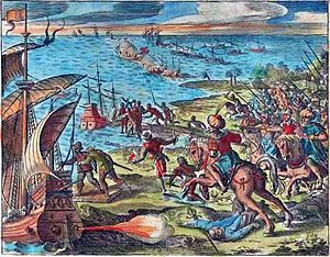 A battle between the Portuguese Armada and Turkish soldiers on horseback in Goa, western India | |||||||
| |||||||
| Belligerents | |||||||
| Commanders and leaders | |||||||
João de Mascarenhas João de Castro | Khadjar Safar † | ||||||
| Strength | |||||||
18 May 440 men[1] 19 July reinforcements consisting of 20 Fustas and 6 caturs with men arrived[1] On 7 November governor Castro arrived with 35 Fustas,caturs, 3 galeons, naus and gales, with 3,000 Portuguese and 300 Indian men[2] | 10,000 men[3] | ||||||
| Casualties and losses | |||||||
more than 200[4] | 3,000 killed 600 prisoners[5] | ||||||
 | |||||||
The Second Siege of Diu was a siege of the Portuguese Indian city of Diu by the Gujarat Sultanate in 1546. It ended with a major Portuguese victory.
Contents
1 Background
2 The siege
3 See also
4 References
Background
At the beginning of the 16th century, the Muslim Sultanate of Gujarat was the principal seapower in India. Gujarat fought the Portuguese fleets in collaboration with the Mamluks. The Portuguese were defeated by a combined Mamluk-Gujarati fleet in 1508, which was in turn destroyed by a Portuguese fleet in the Battle of Diu (1509). By 1536, the Portuguese had gained complete control of Diu, while Gujarat was under attack from the Mughals.
In 1538, the Ottomans, who had taken over Egypt (1517) and Aden (1538), joined hands with the Gujarat Sultanate to launch an anti-Portuguese offensive. They besieged Diu in 1538, but had to retreat.
The siege
After the failed siege of 1538, the Gujarati General Khadjar Safar besieged Diu again in an attempt to recapture the island. The siege lasted seven months from 20 April 1546 to 10 November 1546, during which João de Mascarenhas defended Diu.[6]
The siege ended when a Portuguese fleet under Governor João de Castro arrived and routed the attackers.[6]
Khadjar Safar and his son Muharram Rumi Khan (who were probably of Albanian origin) were both killed during the siege.[7]
See also
- Siege of Diu (1531)
- First Siege of Diu
References
^ ab History of the Portuguese navigation in India, 1497-1600, K. M. Mathew, page 218, 1988
^ History of the Portuguese navigation in India, 1497-1600, K. M. Mathew, page 219, 1988
^ The Cambridge history of the British Empire, John Holland Rose, Ernest Alfred Benians, Arthur Percival Newton, page 16, 1960
^ History of the Portuguese navigation in India, 1497-1600, K. M. Mathew, page 218/219, 1988
^ The Cambridge history of the British Empire, John Holland Rose, Ernest Alfred Benians, Arthur Percival Newton, page 17, 1960
^ ab Tony Jaques, ed. (2007). Dictionary of Battles and Sieges: A Guide to 8,500 Battles from Antiquity Through the Twenty-first Century. 1 (A-E). Greenwood. p. 304. ISBN 978-0-313-33537-2..mw-parser-output cite.citation{font-style:inherit}.mw-parser-output .citation q{quotes:"""""""'""'"}.mw-parser-output .citation .cs1-lock-free a{background:url("//upload.wikimedia.org/wikipedia/commons/thumb/6/65/Lock-green.svg/9px-Lock-green.svg.png")no-repeat;background-position:right .1em center}.mw-parser-output .citation .cs1-lock-limited a,.mw-parser-output .citation .cs1-lock-registration a{background:url("//upload.wikimedia.org/wikipedia/commons/thumb/d/d6/Lock-gray-alt-2.svg/9px-Lock-gray-alt-2.svg.png")no-repeat;background-position:right .1em center}.mw-parser-output .citation .cs1-lock-subscription a{background:url("//upload.wikimedia.org/wikipedia/commons/thumb/a/aa/Lock-red-alt-2.svg/9px-Lock-red-alt-2.svg.png")no-repeat;background-position:right .1em center}.mw-parser-output .cs1-subscription,.mw-parser-output .cs1-registration{color:#555}.mw-parser-output .cs1-subscription span,.mw-parser-output .cs1-registration span{border-bottom:1px dotted;cursor:help}.mw-parser-output .cs1-ws-icon a{background:url("//upload.wikimedia.org/wikipedia/commons/thumb/4/4c/Wikisource-logo.svg/12px-Wikisource-logo.svg.png")no-repeat;background-position:right .1em center}.mw-parser-output code.cs1-code{color:inherit;background:inherit;border:inherit;padding:inherit}.mw-parser-output .cs1-hidden-error{display:none;font-size:100%}.mw-parser-output .cs1-visible-error{font-size:100%}.mw-parser-output .cs1-maint{display:none;color:#33aa33;margin-left:0.3em}.mw-parser-output .cs1-subscription,.mw-parser-output .cs1-registration,.mw-parser-output .cs1-format{font-size:95%}.mw-parser-output .cs1-kern-left,.mw-parser-output .cs1-kern-wl-left{padding-left:0.2em}.mw-parser-output .cs1-kern-right,.mw-parser-output .cs1-kern-wl-right{padding-right:0.2em}
^ Kenneth Warren Chase (2003). Firearms: a global history to 1700 (illustrated ed.). Cambridge University Press. p. 136. ISBN 978-0-521-82274-9.


