Burley Griffin Way
Burley Griffin Way New South Wales | |
|---|---|
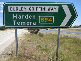 | |
Burley Griffin Way sign on Hume Highway (Eastern end) | |
| General information | |
| Type | Highway |
| Length | 289 km (180 mi) |
| Route number(s) |  B94 B94 |
| Former route number |  State Route 94 State Route 94 |
| Major junctions | |
| East end |  Hume Highway (M31), Hume Highway (M31),Bowning, New South Wales |
 Olympic Highway (A41) Olympic Highway (A41) Goldfields Way (B85) Goldfields Way (B85) Newell Highway (A39) Newell Highway (A39) Irrigation Way Irrigation Way | |
| West end |  Kidman Way (B87), Kidman Way (B87),Griffith, New South Wales |
| Location(s) | |
| Major settlements | Murrumburrah, Wallendbeen, Temora, Ardlethan |
| Highway system | |
| |
Burley Griffin Way is a New South Wales state route, is located in south eastern Australia. Named after the American architect, Walter Burley Griffin, designer of the cities of Canberra and Griffith, the highway links the two cities via Yass and the Barton Highway.
It provides a major link between the towns of Griffith and Yass, and then further north by the Hume Highway, including Sydney and beyond. Economically it provides a link between the agricultural produce of the western Riverina and Murrumbidgee regions and markets such as Sydney. The area it passes through is one of the richest agricultural areas in Australia. Hence, trucks make up a significant proportion of traffic using the road.
Recently, a bypass was constructed west of Bowning, and the Burley Griffin Way was realigned along this road to a new at-grade intersection with the Hume Highway.
Towns
- Bowning
- Murrumburrah
- Harden
- Wallendbeen
- Springdale
- Combaning
- Temora
- Ariah Park
- Ardlethan
- Kamarah
- Barellan
- Binya
- Yenda
- Griffith
See also

- Highways in Australia
- List of highways in New South Wales
References
Road infrastructure in regional New South Wales | ||
|---|---|---|
| Motorways |
|  |
| National highways |
| |
| Highways |
| |
| Local highways |
| |
| Bridges |
| |
| Tunnels |
| |
| Proposals |
| |


