Mangareva
 NASA picture of Mangareva Island | |
 Mangareva | |
| Geography | |
|---|---|
| Location | Pacific Ocean |
| Coordinates | 23°06′34″S 134°57′57″W / 23.10944°S 134.96583°W / -23.10944; -134.96583Coordinates: 23°06′34″S 134°57′57″W / 23.10944°S 134.96583°W / -23.10944; -134.96583 |
| Archipelago | Gambier Islands |
| Area | 15.4 km2 (5.9 sq mi) |
| Length | 8 km (5 mi) |
| Highest elevation | 441 m (1,447 ft) |
| Overseas collectivity | French Polynesia |
| Administrative subdivision | Tuamotus |
| Commune | Gambier Islands |
| Largest settlement | Rikitea |
| Demographics | |
| Population | 1,239[1] (2012) |
Mangareva is the central and largest island of the Gambier Islands in French Polynesia. It is surrounded by smaller islands: Taravai in the southwest, Aukena and Akamaru in the southeast, and islands in the north. Mangareva has a permanent population of 1,239 (2012) and the largest village on the island, Rikitea, is the chief town of the Gambier Islands.
The island is approximately 8 kilometres (5.0 mi) long and, at 15.4 square kilometres (5.9 sq mi), it comprises about 56% of the land area of the whole Gambier group. Mangareva has a high central ridge which runs the length of the island. The highest point in the Gambiers is Mt. Duff, on Mangareva, rising to 441 m along the island's south coast. The island has a large lagoon 24 kilometres (15 mi) in diameter containing reefs whose fish and shellfish helped ancient islanders survive much more successfully than on nearby islands with no reefs.
Contents
1 History
2 Transportation
3 Culture and fiction
3.1 Binary system
4 Gallery
5 See also
6 References
7 External links
History
The Mangarevan language suggests two waves of immigration from the Marquesas, probably via the Eastern Tuamotus. A Marquesan influence is also evident in the style of many ruined marae platforms. Basalt used for making local adze heads can be geochemically traced to quarries on the Marquesas and Society Islands to the north, and to Pitcairn and Henderson Island to the east. Strong similarities between the earliest artefacts here and those from Easter Island have also been identified, suggesting that the island once served as a southern sailing hub comparable to the Society Islands in the more northerly trade wind belt.[2] Mangareva was once heavily forested and supported a large population that traded with other islands via canoes. However, excessive logging by the islanders during the 10th to the 15th centuries resulted in deforestation of the island, with disastrous results for its environment and economy (see Gambier Islands for more details).
The first European to arrive at Mangareva was British Captain James Wilson in 1797 on the ship Duff. Wilson named the island group in honour of Admiral James Gambier, who had helped him to equip his vessel.
Mangareva along with its dependencies in the Gambier Islands were ruled by a line of kings and later regents until the French formally annexed the islands. A French protectorate was requested on 16 February 1844 by King Maputeoa but was never ratified by the French government. On 4 February 1870, Prince Regent Arone Teikatoara and the Mangarevan government formally withdrew the protectorate request and asked the French to not intervene in the kingdom's affairs. After Father Honoré Laval was removed to Tahiti, the native government changed its stance and an agreement between Prince Regent Arone and the French colonial authority in Tahiti was signed reaffirming the protectorate status on 30 November 1871. The Gambier Islands were finally annexed on 21 February 1881 under Prince Regent Bernardo Putairi and approved by the President of France on 30 January 1882.[3]
Transportation
Mangareva is reached by boat from the nearby airport across the lagoon.
Mangareva is an important travel link to Pitcairn Island. Practically the only way a traveler can reach Pitcairn Island is to fly to Tahiti, then to Mangareva. From there, a 32-hour boat ride will take the traveler to the island. Some reach Pitcairn by commercial shipping traffic, but that is less and less common as shipping lanes do not typically pass close to Pitcairn.
Culture and fiction
Painter and author Robert Lee Eskridge's book Manga Reva: The Forgotten Islands (Bobbs Merrill; 1931) offers first-hand observations of the environment, peoples, and traditions of Mangareva. It includes original illustrations and photographs by the author. In 1962, adventure-fiction writer Garland Roark acknowledged Eskridge's work in a foreword to his novel The Witch of Manga Reva. Eskridge also wrote and illustrated a children's book about his visit to Mangareva: South Sea Playmates (Bobbs Merrill; 1933).
Binary system
The Mangarevan people had developed a binary number system 300 years ahead of Europeans.[4] The discovery of the binary system being used as far back as 1450 CE is particularly surprising, given its location.
This old way of common numbering has been all but lost. Because the islands were controlled by the French for such a long period, the Hindu–Arabic numerals with which the West is most familiar has taken its place. Researchers Andrea Bender and Sieghard Beller discovered that mathematicians on the island combined the two number systems into a novel binary system which allowed them to cut down on the number of digits involved in traditional binary systems: for example, 130 is represented in binary as 10000010; In the Mangarevan system, it is represented by VTK. V (varu) stands for 80, T (tataua) is 40, and K (takau) is 10.
Gallery

Mangareva Island, view from the Motu Totegegie

Map of Mangareva dated from 1938

Location within the Gambier Islands
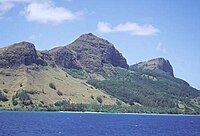
Mt. Duff, 1,200 feet (370 m), the only volcanic remnant of all the original volcanoes which made up the Tuamotu archipelago

St Michael's Cathedral on Mangareva island
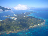
Aerial view

Coastal view


See also
- List of volcanoes in French Polynesia
References
^ "Population". Institut de la statistique de la Polynésie française. Retrieved 5 October 2014..mw-parser-output cite.citation{font-style:inherit}.mw-parser-output .citation q{quotes:"""""""'""'"}.mw-parser-output .citation .cs1-lock-free a{background:url("//upload.wikimedia.org/wikipedia/commons/thumb/6/65/Lock-green.svg/9px-Lock-green.svg.png")no-repeat;background-position:right .1em center}.mw-parser-output .citation .cs1-lock-limited a,.mw-parser-output .citation .cs1-lock-registration a{background:url("//upload.wikimedia.org/wikipedia/commons/thumb/d/d6/Lock-gray-alt-2.svg/9px-Lock-gray-alt-2.svg.png")no-repeat;background-position:right .1em center}.mw-parser-output .citation .cs1-lock-subscription a{background:url("//upload.wikimedia.org/wikipedia/commons/thumb/a/aa/Lock-red-alt-2.svg/9px-Lock-red-alt-2.svg.png")no-repeat;background-position:right .1em center}.mw-parser-output .cs1-subscription,.mw-parser-output .cs1-registration{color:#555}.mw-parser-output .cs1-subscription span,.mw-parser-output .cs1-registration span{border-bottom:1px dotted;cursor:help}.mw-parser-output .cs1-ws-icon a{background:url("//upload.wikimedia.org/wikipedia/commons/thumb/4/4c/Wikisource-logo.svg/12px-Wikisource-logo.svg.png")no-repeat;background-position:right .1em center}.mw-parser-output code.cs1-code{color:inherit;background:inherit;border:inherit;padding:inherit}.mw-parser-output .cs1-hidden-error{display:none;font-size:100%}.mw-parser-output .cs1-visible-error{font-size:100%}.mw-parser-output .cs1-maint{display:none;color:#33aa33;margin-left:0.3em}.mw-parser-output .cs1-subscription,.mw-parser-output .cs1-registration,.mw-parser-output .cs1-format{font-size:95%}.mw-parser-output .cs1-kern-left,.mw-parser-output .cs1-kern-wl-left{padding-left:0.2em}.mw-parser-output .cs1-kern-right,.mw-parser-output .cs1-kern-wl-right{padding-right:0.2em}
^ Crowe, Andrew (2018). Pathway of the Birds: The Voyaging Achievements of Māori and their Polynesian Ancestors. Auckland, New Zealand: Bateman. p. 40-41. ISBN 9781869539610.
^ Gonschor, Lorenz Rudolf (August 2008). Law as a Tool of Oppression and Liberation: Institutional Histories and Perspectives on Political Independence in Hawaiʻi, Tahiti Nui/French Polynesia and Rapa Nui. Honolulu: University of Hawaii at Manoa. pp. 56–59. hdl:10125/20375.
^ Bender, A; Beller, S (2013). "Mangarevan invention of binary steps for easier calculation". Proc. Natl. Acad. Sci. USA. 111 (4): 1322–1327. doi:10.1073/pnas.1309160110. PMC 3910603. PMID 24344278. Retrieved 2 September 2014.
- British Navigators, 1780 to 1800
- Intrepid Polynesian Voyagers
External links
| Wikivoyage has a travel guide for Mangareva. |
| Wikimedia Commons has media related to Mangareva. |
- Mangareva, Tahiti - Death of a People
- Mangareva
Tuamotu Archipelago and Gambier Islands of French Polynesia | |||||||
|---|---|---|---|---|---|---|---|
Tuamotus Gambiers | Islands/Atolls |
| |||||
| Island groups |
| ||||||
| |||||||


