Dallas County, Texas
Dallas County, Texas | ||
|---|---|---|
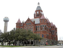 The former Dallas County Courthouse in March 2009 | ||
| ||
 Location in the U.S. state of Texas | ||
 Texas's location in the U.S. | ||
| Founded | March 30, 1846 | |
| Named for | George M. Dallas | |
| Seat | Dallas | |
| Largest city | Dallas | |
| Area | ||
| • Total | 909 sq mi (2,354 km2) | |
| • Land | 873 sq mi (2,261 km2) | |
| • Water | 36 sq mi (93 km2), 4.0% | |
| Population (est.) | ||
| • (2017) | 2,618,148 | |
| • Density | 2,999/sq mi (1,139/km2) | |
| Congressional districts | 5th, 24th, 30th, 32nd, 33rd | |
| Time zone | Central: UTC−6/−5 | |
| Website | www.dallascounty.org | |

Dallas County is a county in the U.S. state of Texas. As of the 2010 census, the population was 2,368,139.[1] It is Texas' second-most populous county and the ninth-most populous in the United States. Its county seat is Dallas,[2] which is also Texas' third-largest city and the ninth-largest city in the United States. The county was founded in 1846 and was possibly named for George Mifflin Dallas, the 11th Vice President of the United States under U.S. President James K. Polk.[disputed ]
Dallas County is included in the Dallas–Fort Worth–Arlington, TX Metropolitan Statistical Area (colloquially referred to as the Dallas-Fort Worth Metroplex).
Contents
1 Geography
1.1 Adjacent counties
2 Demographics
2.1 2015 Texas population estimate program
2.2 2010 Census
3 Government, Courts, and Politics
3.1 Government
3.1.1 County Commissioners[10]
3.1.2 County Officials[10]
3.1.3 Constables[10]
3.1.4 Justices of the Peace[10]
3.2 Courts
3.2.1 County Criminal Courts[10]
3.2.2 County Criminal Courts of Appeals[10]
3.2.3 County Civil Courts[10]
3.2.4 County Probate Courts[10]
3.2.5 Criminal District Courts[10]
3.2.6 Civil District Courts[10]
3.2.7 Family District Courts[10]
3.2.8 Juvenile District Courts[10]
3.2.9 County Services
3.3 Politics
3.3.1 State Board of Education members
3.3.2 Texas State Representatives
3.3.3 Texas State Senators
3.3.4 United States Representatives
4 Education
5 Transportation
5.1 Major highways
5.2 Airports
6 Communities
6.1 Cities (multiple counties)
6.2 Cities
6.3 Towns
6.4 Unincorporated community
6.5 Historical communities
7 See also
8 References
9 External links
Geography
According to the U.S. Census Bureau, the county has a total area of 909 square miles (2,350 km2), of which 873 square miles (2,260 km2) is land and 36 square miles (93 km2) (4.0%) is water.[3]
Adjacent counties
Collin County (north)
Rockwall County (east)
Kaufman County (southeast)
Ellis County (south)
Tarrant County (west)
Denton County (northwest)
Demographics
| Historical population | |||
|---|---|---|---|
| Census | Pop. | %± | |
| 1850 | 2,743 | — | |
| 1860 | 8,665 | 215.9% | |
| 1870 | 13,814 | 59.4% | |
| 1880 | 33,488 | 142.4% | |
| 1890 | 67,042 | 100.2% | |
| 1900 | 82,726 | 23.4% | |
| 1910 | 135,748 | 64.1% | |
| 1920 | 210,551 | 55.1% | |
| 1930 | 325,691 | 54.7% | |
| 1940 | 398,564 | 22.4% | |
| 1950 | 614,799 | 54.3% | |
| 1960 | 951,527 | 54.8% | |
| 1970 | 1,327,321 | 39.5% | |
| 1980 | 1,556,390 | 17.3% | |
| 1990 | 1,852,810 | 19.0% | |
| 2000 | 2,218,899 | 19.8% | |
| 2010 | 2,368,139 | 6.7% | |
| Est. 2017 | 2,618,148 | [4] | 10.6% |
| U.S. Decennial Census[5] 2012 Estimate[1] | |||
2015 Texas population estimate program
As of the 2015 Texas population estimate program, the population of the county was 2,541,528: non-Hispanic whites, 713,835 (28.1%); non-Hispanic blacks, 565,020 (22.2%); other non-Hispanics, 197,082 (7.7%); and Hispanics and Latinos (of any race), 1,065,591 (41.9%).[6]
2010 Census
As of the census[7] of 2010, there were 2,368,139 people, 807,621 households, and 533,837 families residing in the county. The population density was 2,523 people per square mile (974/km²). There were 854,119 housing units at an average density of 971/sq mi (375/km²). The racial makeup of the county was 53.54 White (33.12% Non-Hispanic White), 22.30% Black or African American, 0.10% Native American, 5.15% Asian, 0.06% Pacific Islander, 14.04% from other races, and 2.70% from two or more races. 38.30% of the population were Hispanic or Latino of any race.
There were 807,621 households out of which 35.10% had children under the age of 18 living with them, 46.90% were married couples living together, 14.10% had a female householder with no husband present, and 33.90% were non-families. 27.30% of all households were made up of individuals and 5.90% had someone living alone who was 65 years of age or older. The average household size was 2.71 and the average family size was 3.34. As of the 2010 census, there were about 8.8 same-sex couples per 1,000 households in the county.[8]
In the wider county, the population was spread out with 27.90% under the age of 18, 10.70% from 18 to 24, 34.40% from 25 to 44, 18.90% from 45 to 64, and 8.10% who were 65 years of age or older. The median age was 31 years. For every 100 females there were 99.80 males. For every 100 females age 18 and over, there were 98.00 males.
The median income for a household in the county was US$43,324, and the median income for a family was $49,062. Males had a median income of $34,988 versus $29,539 for females. The per capita income for the county was $22,603. About 10.60% of families and 13.40% of the population were below the poverty line, including 18.00% of those under age 18 and 10.50% of those age 65 or over.
Government, Courts, and Politics
Government
Dallas County, like all counties in Texas, is governed by a Commissioners Court. This court consists of the county judge (the chairperson of the court), who is elected county-wide, and four commissioners who are elected by the voters in each of four precincts.
The Commissioners Court is the policy-making body for the county; in addition, the county judge is the senior executive and administrative position in the county. The Commissioners Court sets the county tax rate, adopts the budget, appoints boards and commissions, approves grants and personnel actions, and oversees the administration of county government. Each commissioner also supervises a Road and Bridge District. The Commissioners Court also approves the budget and sets the tax rate for the hospital district, which is charged with the responsibility for providing acute medical care for citizens who otherwise would not receive adequate medical services.[9]
County Commissioners[10]
Office | Name | Party | |
|---|---|---|---|
| | County Judge | Clay Jenkins | Democratic |
| | Commissioner, Precinct 1 | Theresa Daniel | Democratic |
| | Commissioner, Precinct 2 | Mike Cantrell | Republican |
| | Commissioner, Precinct 3 | John Wiley Price | Democratic |
| | Commissioner, Precinct 4 | Elba Garcia | Democratic |
County Officials[10]
| Office | Name | Party | |
|---|---|---|---|
| | County Clerk | John Warren | Democratic |
| | Criminal District Attorney | Faith Johnson | Republican |
| | District Clerk | Felicia Pitre | Democratic |
| | Sheriff | Marian Brown | Democratic |
| | Tax Assessor-Collector | John Ames | Democratic |
| | Treasurer | Pauline Medrano | Democratic |
Constables[10]
| Office | Name | Party | |
|---|---|---|---|
| | Constable, Precinct 1 | Tracey Gulley | Democratic |
| | Constable, Precinct 2 | Ray Nichols | Republican |
| | Constable, Precinct 3 | Ben Adamcik | Republican |
| | Constable, Precinct 4 | Roy Williams, Jr. | Democratic |
| | Constable, Precinct 5 | Beth Villarreal | Democratic |
Justices of the Peace[10]
| Office | Name | Party | |
|---|---|---|---|
| | Justice of the Peace, Precinct 1, Place 1 | Thomas G. Jones | Democratic |
| | Justice of the Peace, Precinct 1, Place 2 | Valencia Nash | Democratic |
| | Justice of the Peace, Precinct 2, Place 1 | Brian Hutcheson | Republican |
| | Justice of the Peace, Precinct 2, Place 2 | Bill Metzger | Republican |
| | Justice of the Peace, Precinct 3, Place 1 | Al Cercone | Republican |
| | Justice of the Peace, Precinct 3, Place 2 | Steven L. Seider | Republican |
| | Justice of the Peace, Precinct 4, Place 1 | Norris "Stretch" Rideaux | Democratic |
| | Justice of the Peace, Precinct 4, Place 2 | Katy Hubener | Democratic |
| | Justice of the Peace, Precinct 5, Place 1 | Sara Martinez | Democratic |
| | Justice of the Peace, Precinct 5, Place 2 | Juan Jasso | Democratic |
Courts
County Criminal Courts[10]
| Office | Name | Party | |
|---|---|---|---|
| | County Criminal Court No. 1 | Dan Patterson | Democratic |
| | County Criminal Court No. 2 | Julia Hayes | Democratic |
| | County Criminal Court No. 3 | Doug Skemp | Democratic |
| | County Criminal Court No. 4 | Nancy Mulder | Democratic |
| | County Criminal Court No. 5 | Lisa Green | Democratic |
| | County Criminal Court No. 6 | Angela M. King | Democratic |
| | County Criminal Court No. 7 | Elizabeth Crowder | Democratic |
| | County Criminal Court No. 8 | Tina Yoo Clinton | Democratic |
| | County Criminal Court No. 9 | Peggy hoffman | Democratic |
| | County Criminal Court No. 10 | Roberto Canas, Jr. | Democratic |
| | County Criminal Court No. 11 | Shequitta Kelly | Democratic |
County Criminal Courts of Appeals[10]
| Office | Name | Party | |
|---|---|---|---|
| | County Criminal Court of Appeals No. 1 | Kristin Wade | Democratic |
| | County Criminal Court of Appeals No. 2 | Jeff Rosenfield | Democratic |
County Civil Courts[10]
| Office | Name | Party | |
|---|---|---|---|
| | County Court at Law No. 1 | D'Metria Benson | Democratic |
| | County Court at Law No. 2 | King Fifer | Democratic |
| | County Court at Law No. 3 | Sally Montgomery | Democratic |
| | County Court at Law No. 4 | Ken Tapscott | Democratic |
| | County Court at Law No. 5 | Mark Greenberg | Democratic |
County Probate Courts[10]
| Office | Name | Party | |
|---|---|---|---|
| | County Probate Court No. 1 | Brenda Hull Thompson | Democratic |
| | County Probate Court No. 2 | Ingrid Michelle Warren | Democratic |
| | County Probate Court No. 3 | Margaret Jones-Johnson | Democratic |
Criminal District Courts[10]
| Office | Name | Party | |
|---|---|---|---|
| | Criminal District Court No. 1 | Robert Burns | Democratic |
| | Criminal District Court No. 2 | Nancy Kennedy | Democratic |
| | Criminal District Court No. 3 | Gracie Lewis | Democratic |
| | Criminal District Court No. 4 | Dominique Collins | Democratic |
| | Criminal District Court No. 5 | Carter Thompson | Democratic |
| | Criminal District Court No. 6 | Jeanine Howard | Democratic |
| | Criminal District Court No. 7 | Vacant | |
| | 194th District Court | Ernest White III | Democratic |
| | 195th District Court | Hector Garza | Democratic |
| | 203rd District Court | Teresa Hawthorne | Democratic |
| | 204th District Court | Tammy Kemp | Democratic |
| | 265th District Court | Jennifer Bennett | Democratic |
| | 282nd District Court | Amber Givens-Davis | Democratic |
| | 283rd District Court | Vacant | |
| | 291st District Court | Stephanie Mitchell | Democratic |
| | 292nd District Court | Brandon Birmingham | Democratic |
| | 363rd District Court | Tracy Holmes | Democratic |
Civil District Courts[10]
| Office | Name | Party | |
|---|---|---|---|
| | 14th District Court | Eric Moyé | Democratic |
| | 44th District Court | Bonnie Lee Goldstein | Democratic |
| | 68th District Court | Martin Hoffman | Democratic |
| | 95th District Court | Ken Molberg | Democratic |
| | 101st District Court | Staci Williams | Democratic |
| | 116th District Court | Tonya Parker | Democratic |
| | 134th District Court | Dale Tillery | Democratic |
| | 160th District Court | Jim Jordan | Democratic |
| | 162nd District Court | Maricela Moore | Democratic |
| | 191st District Court | Gena Slaughter | Democratic |
| | 192nd District Court | Craig Smith | Democratic |
| | 193rd District Court | Carl Ginsberg | Democratic |
| | 298th District Court | Emily Tobolowsky | Democratic |
Family District Courts[10]
| Office | Name | Party | |
|---|---|---|---|
| | 254th District Court | Darlene Ewing | Democratic |
| | 255th District Court | Kim Cooks | Democratic |
| | 256th District Court | David Lopez | Democratic |
| | 301st District Court | Mary Brown | Democratic |
| | 302nd District Court | Tena Callahan | Democratic |
| | 303rd District Court | Dennise Garcia | Democratic |
| | 330th District Court | Andrea Plumlee | Democratic |
Juvenile District Courts[10]
| Office | Name | Party | |
|---|---|---|---|
| | 304th District Court | Andrea Martin | Democratic |
| | 305th District Court | Cheryl Lee Shannon | Democratic |
County Services
The Parkland Health & Hospital System (Dallas County Hospital District) operates the Parkland Memorial Hospital and various health centers.
The Commissioners Court meets the first and third Tuesday at the Commissioners Courtroom located in the Dallas County Administration Building at 411 Elm St., corner of Elm and Houston streets. The building was the headquarters of the Texas School Book Depository Company until 1970. Assassin Lee Harvey Oswald shot President John F. Kennedy from a window located on the sixth floor which today houses the Sixth Floor Museum dedicated to the late president's memory.
Acts of the commissioners court are known as 'court orders'. These orders include setting county policies and procedures, issuing contracts, authorizing expenditures, and managing county resources and departments. Most importantly, the commissioners court sets the annual tax rate and the budget for Dallas County government and the courts. The commissioners also set the tax rate and budget for the Dallas County Hospital District which operates Parkland Hospital.
The commissioners court has direct control over all county offices and departments not otherwise administered by a county elected official. Those departments include Dallas County Elections, Health and Human Services, Facilities Management, Parks and Open Space Program, I.T. Services, Homeland Security and Emergency Services, among others. Through their budget making powers, the commissioners exercise indirect control over the District Attorney's office, Sheriff, District Clerk, County Clerk and County Treasurer. The commissioners also set the budget for each of the District, County, and Justice courts.
Dallas County employs a commissioners court administrator who is responsible for the day-to-day management of the commissioners court and implementing the Dallas County Master Plan and the directives of the commissioners court. The current commissioners court administrator is Darryl Martin who was hired by the commissioners in 2008.
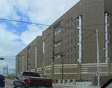
Dallas County Jail, 111 West Commerce Street
Dallas County operates several jail facilities. They include:[11]
- 111 Riverfront Blvd (Dallas)
- North Tower Jail
- South Tower Jail - also known as the "Suzanne Kays Tower"
- West Tower Jail
- Government Center Jail - 600 Commerce Street (Dallas)
- Decker Detention Center - 899 North Stemmons Freeway (Dallas)
- (formerly) Suzanne Kays Jail - 521 North Industrial Boulevard (Dallas) - population integrated into the South Tower; demolished to clear way for the Trinity River Project[12]
Texas Department of Criminal Justice operates the Hutchins State Jail for men in an unincorporated area adjacent to Hutchins.[13]Corrections Corporation of America operates the Dawson Unit, a co-gender state jail in Downtown Dallas, under contract.[14]
Federal Correctional Institution, Seagoville, is located in Seagoville.
Politics
Dallas County's post-war growth transformed it from a Democratic Solid South stronghold into a conservative sunbelt county that voted for the Republican presidential candidate in every election from 1952 to 2004, except when Texas native Lyndon B. Johnson successfully ran for a full term as President on the Democratic ticket in 1964. In the 2004 election, Democrats won their first countywide administrative office since 1986 by electing Lupe Valdez to the office of Dallas County Sheriff. The last Democratic countywide administrator was D. Connally elected County Surveyor prior to the office's abolition. Democrats also won three district court benches in 2004. Two years later in 2006, Democrats swept every contested countywide race including County Judge, District Clerk, County Clerk, District Attorney and County Treasurer as well as every contested judicial seat.
Starting in 1992, Dallas County began voting more Democratic than the state of Texas as a whole, with relatively narrow wins from 1992 to 2004 even as the Republican nominee won Texas easily. This trend culminated in 2008 when Barack Obama won Dallas County with a substantial margin. Obama's coattails allowed Democrats to win the remaining Republican held judicial seats. In 2012, Obama won Dallas County by virtually the same margin as he had done in 2008. In 2016, Hillary Clinton increased the Democratic margin of victory even further. She became the first Democrat to win 60% of Dallas County since Franklin D. Roosevelt in 1944.
| Year | Republican | Democratic | Third parties |
|---|---|---|---|
2016 | 34.3% 262,945 | 60.2% 461,080 | 5.4% 41,657 |
2012 | 41.6% 295,813 | 57.0% 405,571 | 1.4% 10,228 |
2008 | 41.9% 310,000 | 57.2% 422,989 | 1.0% 7,085 |
2004 | 50.4% 346,246 | 49.0% 336,641 | 0.7% 4,822 |
2000 | 52.6% 322,345 | 44.9% 275,308 | 2.5% 15,386 |
1996 | 46.8% 260,058 | 46.0% 255,766 | 7.2% 40,129 |
1992 | 38.7% 256,007 | 35.0% 231,412 | 26.3% 173,833 |
1988 | 58.4% 347,094 | 40.9% 243,198 | 0.7% 4,246 |
1984 | 66.4% 405,444 | 33.4% 203,592 | 0.2% 1,460 |
1980 | 59.2% 306,682 | 36.8% 190,459 | 4.1% 21,072 |
1976 | 56.7% 263,081 | 42.3% 196,303 | 1.1% 5,001 |
1972 | 69.5% 305,112 | 29.6% 129,662 | 0.9% 4,021 |
1968 | 50.7% 184,193 | 34.1% 123,809 | 15.3% 55,552 |
1964 | 45.1% 137,065 | 54.7% 166,472 | 0.2% 621 |
1960 | 62.2% 149,369 | 37.0% 88,876 | 0.9% 2,054 |
1956 | 65.1% 125,361 | 34.0% 65,472 | 1.0% 1,862 |
1952 | 62.7% 118,218 | 36.8% 69,394 | 0.5% 850 |
1948 | 37.8% 35,664 | 50.3% 47,464 | 11.9% 11,216 |
1944 | 22.4% 21,099 | 64.8% 60,909 | 12.8% 12,028 |
1940 | 25.1% 16,574 | 74.7% 49,431 | 0.2% 131 |
1936 | 14.5% 7,204 | 84.9% 42,153 | 0.6% 300 |
1932 | 19.1% 8,919 | 80.1% 37,363 | 0.8% 371 |
1928 | 60.9% 27,272 | 38.9% 17,437 | 0.2% 78 |
1924 | 21.6% 8,618 | 75.8% 30,207 | 2.5% 1,012 |
1920 | 23.4% 4,984 | 67.4% 14,390 | 9.2% 1,973 |
1916 | 15.7% 2,554 | 82.5% 13,410 | 1.8% 289 |
1912 | 6.1% 590 | 79.8% 7,725 | 14.1% 1,367 |
The Democratic gains in the county are primarily due to the exurban migration of disproportionately conservative, Republican-voting residents to the neighboring counties of Collin, Denton and Rockwall[16] As a result, those counties have become more solidly Republican. The tremendous growth in these neighboring counties was part of a larger explosion in exurban growth throughout the nation over the last decade which coincided with the real estate bust in 2007.[17] In North Texas, exurban growth was accelerated by transportation infrastructure expansion including the extensions of U.S. 75 north and the Dallas North Tollway in the mid 1990s, and the completion of the George Bush Turnpike after 2001. These and other enhancements opened up vast tracts of farmland to new housing developments.[18]
Dallas County has three openly LGBT elected county officials. Lupe Valdez elected Sheriff in 2004 and a candidate for reelection in 2012; Jim Foster, elected county judge in 2006 serving one term then defeated in the Democratic primary in 2010; and Gary Fitzsimmons, elected District Clerk in 2006.[19]
Although Dallas County has become much friendlier to Democrats in Presidential and Senate elections since 1992, it remains a mostly Republican county in the U.S. House of Representatives and the Texas Legislature as a result of the legislature having engaged in what a federal district court has found to be illegal gerrymandering[20] the districts to pack heavily Democratic non-whites into very few districts and split the rest of them with more conservative white areas in Dallas and surrounding counties.
State Board of Education members
| District | Name | Party | |
|---|---|---|---|
| | District 11 | Patricia Hardy | Republican |
| | District 12 | Geraldine Miller | Republican |
| | District 13 | Erika Beltran | Democratic |
Texas State Representatives
| District | Name | Party | Residence | |
|---|---|---|---|---|
| | District 100 | Eric Johnson | Democratic | Dallas |
| | District 102 | Linda Koop | Republican | Dallas |
| | District 103 | Rafael Anchia | Democratic | Dallas |
| | District 104 | Roberto R. Alonzo | Democratic | Dallas |
| | District 105 | Rodney Anderson | Republican | Grand Prairie |
| | District 107 | Victoria Neave | Democratic | Dallas |
| | District 108 | Morgan Meyer | Republican | Dallas |
| | District 109 | Helen Giddings | Democratic | De Soto |
| | District 110 | Toni Rose | Democratic | Dallas |
| | District 111 | Yvonne Davis | Democratic | Dallas |
| | District 112 | Angie Chen Button | Republican | Richardson |
| | District 113 | Cindy Burkett | Republican | Garland |
| | District 114 | Jason Villalba | Republican | Dallas |
| | District 115 | Matt Rinaldi | Republican | Irving |
Texas State Senators
| District | Name | Party | Residence | |
|---|---|---|---|---|
| | District 2 | Bob Hall | Republican | Edgewood (Van Zandt County) |
| | District 8 | Van Taylor | Republican | Plano |
| | District 9 | Kelly Hancock | Republican | Fort Worth |
| | District 16 | Don Huffines | Republican | Dallas |
| | District 23 | Royce West | Democratic | Dallas |
United States Representatives
| District | Name | Party | Residence | |
|---|---|---|---|---|
| | Texas's 5th congressional district | Jeb Hensarling | Republican | Dallas |
| | Texas's 24th congressional district | Kenny Marchant | Republican | Coppell |
| | Texas's 30th congressional district | Eddie Bernice Johnson | Democratic | Dallas |
| | Texas's 32nd congressional district | Pete Sessions | Republican | Dallas |
| | Texas's 33rd congressional district | Marc Veasey | Democratic | Fort Worth |
Education
The following school districts serve Dallas County:
|
|
Transportation
Dallas Area Rapid Transit provides bus and rail service to many cities in Dallas County, with Dallas being the largest.
The Trinity Railway Express provides commuter rail service to Tarrant County, including downtown Fort Worth.
Major highways
 I-20
I-20
 I-30
I-30
 I-35E
I-35E
 I-45
I-45
 BL I-45
 I-345
I-345
 I-635
I-635
 US 67
US 67
 US 75
US 75
 US 77
US 77
 US 80
US 80
 US 175
 Dallas North Tollway
 Pres. George Bush Tpk.
 Loop 12
 SH 66
SH 66
 SH 78
SH 78
 SH 114
 SH 121
 SH 161
 SH 183
 SH 190
 SH 289
 SH 342
 SH 352
 SH 356
 Spur 408
 FM 1382
NOTE: US 67 and US 77 are not signed fully along their routes in Dallas County.
Airports
Love Field, located in Dallas and in Dallas County, serves only domestic passengers.
Dallas/Fort Worth International Airport is partially located in the city of Irving in Dallas County, and Grapevine and Euless in Tarrant County.
Communities
Cities (multiple counties)
Carrollton (partly in Denton County and a small part in Collin County)
Cedar Hill (small part in Ellis County)
Combine (partly in Kaufman County)
Coppell (small part in Denton County)
Dallas (county seat) (small parts in Collin, Denton, Kaufman and Rockwall counties)
Ferris (mostly in Ellis County)
Garland (small parts in Collin and Rockwall counties)
Glenn Heights (partly in Ellis County)
Grand Prairie (partly in Tarrant County and a small part in Ellis County)
Grapevine (mostly in Tarrant County and a small part in Denton County)
Lewisville (mostly in Denton County)
Mesquite (small part in Kaufman County)
Ovilla (mostly in Ellis County)
Richardson (small part in Collin County)
Rowlett (small part in Rockwall County)
Sachse (small part in Collin County)
Seagoville (small part in Kaufman County)
Wylie (mostly in Collin County and a small part in Rockwall County)
Cities
- Balch Springs
- Cockrell Hill
- DeSoto
- Duncanville
- Farmers Branch
- Hutchins
- Irving
- Lancaster
- University Park
- Wilmer
Towns
- Addison
- Highland Park
- Sunnyvale
Unincorporated community
- Sand Branch
Historical communities
Alpha (not incorporated)
Buckingham (Annexed by Richardson in 1996)
Cedar Springs (Annexed by Dallas First Settled in February 1841. In 1929 the community was annexed by the city of Dallas. [1])
Duck Creek (merged into Garland in 1887)- East Dallas (annexed by the city of Dallas in 1890 but was once a city of its own)
- Embree (merged into Garland in 1887)
Fruitdale (annexed by Dallas in 1964)
Hatterville (Merged into Sunnyvale in 1953)
Hord's Ridge (Merged by Oak Cliff in 1887 per The Handbook of Texas [2])
Kleberg (Absorbed by City of Dallas in 1978)
La Reunion (Absorbed by City of Dallas in 1860)- Letot (Northwest Dallas County, annexed by Dallas)[21]
- Liberty Grove
Little Egypt[22]
Long Creek (Merged into Sunnyvale in 1953)- Meaders
New Hope (Merged into Sunnyvale in 1953 - not to be confused with the Collin County town of the same name)
Noel Junction not incorporated, Addison/Dallas
Oak Cliff (Annexed by Dallas in 1903)- Penn Springs (Annexed by Duncanville in 1947)
Pleasant Grove (Annexed by Dallas by 1962)
Preston Hollow (Annexed by Dallas in 1945)
Renner (annexed by Dallas in 1977)
Rylie (annexed by Dallas in 1978)- Scyene
Trinity Mills (Annexed by Carrollton)[23]
Tripp (Merged into Sunnyvale in 1953)
See also
- Dallas County District Attorney
- List of museums in North Texas
- National Register of Historic Places listings in Dallas County, Texas
- Recorded Texas Historic Landmarks in Dallas County
References
^ ab "State & County QuickFacts". United States Census Bureau. Archived from the original on July 9, 2011. Retrieved December 10, 2013..mw-parser-output cite.citation{font-style:inherit}.mw-parser-output q{quotes:"""""""'""'"}.mw-parser-output code.cs1-code{color:inherit;background:inherit;border:inherit;padding:inherit}.mw-parser-output .cs1-lock-free a{background:url("//upload.wikimedia.org/wikipedia/commons/thumb/6/65/Lock-green.svg/9px-Lock-green.svg.png")no-repeat;background-position:right .1em center}.mw-parser-output .cs1-lock-limited a,.mw-parser-output .cs1-lock-registration a{background:url("//upload.wikimedia.org/wikipedia/commons/thumb/d/d6/Lock-gray-alt-2.svg/9px-Lock-gray-alt-2.svg.png")no-repeat;background-position:right .1em center}.mw-parser-output .cs1-lock-subscription a{background:url("//upload.wikimedia.org/wikipedia/commons/thumb/a/aa/Lock-red-alt-2.svg/9px-Lock-red-alt-2.svg.png")no-repeat;background-position:right .1em center}.mw-parser-output .cs1-subscription,.mw-parser-output .cs1-registration{color:#555}.mw-parser-output .cs1-subscription span,.mw-parser-output .cs1-registration span{border-bottom:1px dotted;cursor:help}.mw-parser-output .cs1-hidden-error{display:none;font-size:100%}.mw-parser-output .cs1-visible-error{font-size:100%}.mw-parser-output .cs1-subscription,.mw-parser-output .cs1-registration,.mw-parser-output .cs1-format{font-size:95%}.mw-parser-output .cs1-kern-left,.mw-parser-output .cs1-kern-wl-left{padding-left:0.2em}.mw-parser-output .cs1-kern-right,.mw-parser-output .cs1-kern-wl-right{padding-right:0.2em}
^ "Find a County". National Association of Counties. Archived from the original on May 31, 2011. Retrieved 2011-06-07.
^ "US Gazetteer files: 2010, 2000, and 1990". United States Census Bureau. 2011-02-12. Retrieved 2011-04-23.
^ "American FactFinder". Retrieved March 23, 2018.
^ "U.S. Decennial Census". Census.gov. Archived from the original on May 12, 2015. Retrieved December 10, 2013.
^ Estimates of the Population by Age, Sex, and Race/Ethnicity for July 1, 2015 for State of Texas (PDF), July 15, 2015, retrieved June 8, 2017
^ "American FactFinder". United States Census Bureau. Archived from the original on September 11, 2013. Retrieved 2011-05-14.
^ Where Same-Sex Couples Live, June 26, 2015, retrieved July 6, 2015
^ "Dallas County". www.dallascounty.org.
^ abcdefghijkl "Dallas County, TX Elections". www.dallascountyvotes.org. Retrieved 2017-12-04.
^ "Jail Information." Dallas County Sheriff's Office. Accessed September 14, 2008.
^ Krause, Kevin. Suzanne Kays jail to close in Dallas this week." The Dallas Morning News. April 14, 2009. Retrieved on June 3, 2013.
^ "HUTCHINS (HJ) Archived 2008-09-23 at the Wayback Machine.." Texas Department of Criminal Justice. Accessed September 14, 2008.
^ "DAWSON (JD) Archived 2013-06-03 at the Wayback Machine.." Texas Department of Criminal Justice. Retrieved on June 3, 2013.
^ Leip, David. "Dave Leip's Atlas of U.S. Presidential Elections". uselectionatlas.org. Retrieved 2018-07-21.
^ Wallsten, Peter (2004-06-28). "Bush Sees 'Fertile Soil' in Exurbia". The Los Angeles Times. Retrieved 2012-06-25.
^ Tavernise, Sabrina (April 4, 2012). "Census Data Offers Look at Effects of Recession". The New York Times. Retrieved 2012-06-25.
^ Kim, Theodore (February 4, 2012). "North Texas Growth Sprang from Pro-Growth Policies". Dallas Morning News. Retrieved 2012-06-25.
^ Cloud, John (2007-05-17). "The Lavender Heart of Texas". Time magazine. Retrieved 2012-06-18.
^ Barragan, James (20 April 2018). "Redistricting Redux". Dallas News. Retrieved 15 June 2018.
^ Rose-Mary Rumbley, "LETOT, CLEMENT" Handbook of Texas Online, accessed December 26, 2010.
^ "Little Egypt,TX" in the Handbook of Texas Online, by Lisa C. Maxwell; accessed 05 December 2015.
^ "Trinity Mills, TX" from the Handbook of Texas Online. By Matthew Hayes Nall. Retrieved on 31 March 2007.
External links
| Wikimedia Commons has media related to Dallas County, Texas. |
- Dallas County Government official site
Dallas County from the Handbook of Texas Online
History of Dallas County, Texas: from 1837 to 1887 by John Henry Brown, published 1887, hosted by the Portal to Texas History.
Memorial and biographical history of Dallas County, Texas published 1892, hosted by the Portal to Texas History.
Official directory, taxpayers of Dallas County, Texas published 1896, hosted by the Portal to Texas History.
Dallas County Code (ordinances / regulations) from Municode
Places adjacent to Dallas County, Texas | ||||||||||
|---|---|---|---|---|---|---|---|---|---|---|
| ||||||||||
Municipalities and communities of Dallas County, Texas, United States | ||
|---|---|---|
County seat: Dallas‡ | ||
| Cities |
|  |
| Towns |
| |
| Unincorporated communities |
| |
| Historical communities |
| |
| Footnotes | ‡This populated place also has portions in an adjacent county or counties | |
|
Austin (capital) | ||
| Topics |
|  Seal of Texas |
| Society |
| |
| Regions |
| |
| Metropolitan areas |
| |
| Counties | See: List of counties in Texas | |
Coordinates: 32°46′N 96°47′W / 32.77°N 96.78°W / 32.77; -96.78
Authority control |
|
|---|


