100th meridian west

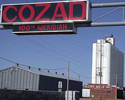
Sign marking the 100th meridian in Cozad, Nebraska
The meridian 100° west of Greenwich is a line of longitude that extends from the North Pole across the Arctic Ocean, North America, the Pacific Ocean, the Southern Ocean, and Antarctica to the South Pole.
The 100th meridian west forms a great circle with the 80th meridian east.
Contents
1 From Pole to Pole
2 United States
3 In popular culture
4 See also
From Pole to Pole
Starting at the North Pole and heading south to the South Pole, the 100th meridian west passes through:
Co-ordinates
Country, territory or sea
Notes
90°0′N 100°0′W / 90.000°N 100.000°W / 90.000; -100.000 (Arctic Ocean)
Arctic Ocean
80°6′N 100°0′W / 80.100°N 100.000°W / 80.100; -100.000 (Canada)
 Canada
Nunavut — Meighen Island
79°52′N 100°0′W / 79.867°N 100.000°W / 79.867; -100.000 (Peary Channel)
Peary Channel
78°44′N 100°0′W / 78.733°N 100.000°W / 78.733; -100.000 (Canada)
Canada
Nunavut — Ellef Ringnes Island
77°48′N 100°0′W / 77.800°N 100.000°W / 77.800; -100.000
Unnamed waterbody
76°45′N 100°0′W / 76.750°N 100.000°W / 76.750; -100.000 (Canada)
Canada
Nunavut — Berkeley Islands and Bathurst Island
74°59′N 100°0′W / 74.983°N 100.000°W / 74.983; -100.000 (Parry Channel)
Parry Channel
73°57′N 100°0′W / 73.950°N 100.000°W / 73.950; -100.000 (Canada)
Canada
Nunavut — Prince of Wales Island
71°52′N 100°0′W / 71.867°N 100.000°W / 71.867; -100.000 (M'Clintock Channel)
M'Clintock Channel
70°35′N 100°0′W / 70.583°N 100.000°W / 70.583; -100.000 (Larsen Sound)
Larsen Sound
Passing just east of Gateshead Island, Nunavut, Canada (at 70°35′N 100°9′W / 70.583°N 100.150°W / 70.583; -100.150 (Gateshead Island))
69°58′N 100°0′W / 69.967°N 100.000°W / 69.967; -100.000 (Victoria Strait)
Victoria Strait
69°3′N 100°0′W / 69.050°N 100.000°W / 69.050; -100.000 (Canada)
Canada
Nunavut — Royal Geographical Society Islands
68°57′N 100°0′W / 68.950°N 100.000°W / 68.950; -100.000 (Queen Maud Gulf)
Queen Maud Gulf
Passing just east of Hat Island, Nunavut, Canada (at 68°18′N 100°2′W / 68.300°N 100.033°W / 68.300; -100.033 (Hat Island))
67°50′N 100°0′W / 67.833°N 100.000°W / 67.833; -100.000 (Canada)
Canada
Nunavut
Manitoba — from 60°0′N 100°0′W / 60.000°N 100.000°W / 60.000; -100.000 (Manitoba)
49°0′N 100°0′W / 49.000°N 100.000°W / 49.000; -100.000 (United States (North Dakota))
 United States
North Dakota
South Dakota — from 45°56′N 100°0′W / 45.933°N 100.000°W / 45.933; -100.000 (South Dakota)
Nebraska — from 43°0′N 100°0′W / 43.000°N 100.000°W / 43.000; -100.000 (Nebraska)
Kansas — from 40°0′N 100°0′W / 40.000°N 100.000°W / 40.000; -100.000 (Kansas)
Oklahoma — from 37°0′N 100°0′W / 37.000°N 100.000°W / 37.000; -100.000 (Oklahoma)
Texas / Oklahoma border — from 36°30′N 100°0′W / 36.500°N 100.000°W / 36.500; -100.000 (Texas / Oklahoma border)
Texas — from 34°34′N 100°0′W / 34.567°N 100.000°W / 34.567; -100.000 (Texas)
28°0′N 100°0′W / 28.000°N 100.000°W / 28.000; -100.000 (Mexico)
 Mexico
Coahuila
Nuevo León — from 27°37′N 100°0′W / 27.617°N 100.000°W / 27.617; -100.000 (Nuevo León)
Tamaulipas — from 23°24′N 100°0′W / 23.400°N 100.000°W / 23.400; -100.000 (Tamaulipas)
San Luis Potosí — from 23°10′N 100°0′W / 23.167°N 100.000°W / 23.167; -100.000 (San Luis Potosí)
Tamaulipas — from 22°54′N 100°0′W / 22.900°N 100.000°W / 22.900; -100.000 (Tamaulipas)
San Luis Potosí — from 22°50′N 100°0′W / 22.833°N 100.000°W / 22.833; -100.000 (San Luis Potosí)
Guanajuato — from 21°30′N 100°0′W / 21.500°N 100.000°W / 21.500; -100.000 (Guanajuato)
Querétaro — from 21°12′N 100°0′W / 21.200°N 100.000°W / 21.200; -100.000 (Querétaro)
Mexico State — from 20°6′N 100°0′W / 20.100°N 100.000°W / 20.100; -100.000 (Mexico State)
Guerrero — from 18°35′N 100°0′W / 18.583°N 100.000°W / 18.583; -100.000 (Guerro)
16°54′N 100°0′W / 16.900°N 100.000°W / 16.900; -100.000 (Pacific Ocean)
Pacific Ocean
60°0′S 100°0′W / 60.000°S 100.000°W / -60.000; -100.000 (Southern Ocean)
Southern Ocean
71°55′S 100°0′W / 71.917°S 100.000°W / -71.917; -100.000 (Antarctica)
Antarctica
Unclaimed territory
United States

Part of the border between Texas and Oklahoma is defined by the 100th meridian west.
In the United States the meridian 100° west of Greenwich forms the eastern border of the Texas panhandle with Oklahoma (which traces its origin to the Adams-Onís Treaty in 1819 which settled the border between New Spain and the United States between the Red River and Arkansas River). Dodge City, Kansas lies exactly at the intersection of the Arkansas River and the 100th meridian.
In the central Great Plains, the meridian roughly marks the western boundary of the normal reach of moist air from the Gulf of Mexico, and the approximate boundary (although some areas do push the boundary slightly farther east) between the semi-arid climate to the west and the humid continental (north of about 37°N) and humid subtropical (south of about 37°N) climates to the east. The type of agriculture west of the meridian typically relies heavily on irrigation. Historically the meridian has often been taken as a rough boundary between the eastern and western United States. White settlement, spreading westward after the American Civil War, settled the area around this meridian during the 1870s.
A sign across U.S. Highway 30 in Cozad, Nebraska, marks the place where the 100th meridian intersects with the routes of the Oregon Trail, Pony Express, transcontinental railroad, and the Lincoln Highway.
In popular culture
Wallace Stegner's Beyond the Hundredth Meridian (1954), is a biography of John Wesley Powell, an explorer of the American West.
The song "At the Hundredth Meridian" by The Tragically Hip is about the 100th meridian west, specifically in Canada, and how it has traditionally been considered "where the great plains begin."
| Preceded by 99th meridian west | 100th meridian west forms a great circle with 80th meridian east | Succeeded by 101st meridian west |
See also
- Rain follows the plow
Circles of latitude / meridians | |
|---|---|
 Equator Tropic of Cancer Tropic of Capricorn Arctic Circle Antarctic Circle Equator Tropic of Cancer Tropic of Capricorn Arctic Circle Antarctic Circle Equator Tropic of Cancer Tropic of Capricorn Arctic Circle Antarctic Circle W 0° E 30° 60° 90° 120° 150° 180° 30° 60° 90° 120° 150° 180° 5° 15° 25° 35° 45° 55° 65° 75° 85° 95° 105° 115° 125° 135° 145° 155° 165° 175° 5° 15° 25° 35° 45° 55° 65° 75° 85° 95° 105° 115° 125° 135° 145° 155° 165° 175° 10° 20° 40° 50° 70° 80° 100° 110° 130° 140° 160° 170° 10° 20° 40° 50° 70° 80° 100° 110° 130° 140° 160° 170° 0° 10° 20° 30° 40° 50° 60° 70° 80° 90° 10° 20° 30° 40° 50° 60° 70° 80° 90° 5° N 15° 25° 35° 45° 55° 65° 75° 85° 5° S 15° 25° 35° 45° 55° 65° 75° 85° 45x90 45x90 45x90 45x90 |


