Salient (geography)

Map of Namibia showing the Caprivi Strip in the country's northeast.
A salient is an elongated protrusion of a geopolitical entity, such as a subnational entity or a sovereign state.
While similar to a peninsula in shape, a salient is not surrounded by water on three sides. Instead, it has a land border on at least two sides and extends out from the larger geographical body of the administrative unit.
In American English the term panhandle is often used to describe a relatively long and narrow salient, such as the westernmost extension of Oklahoma. Less common descriptors include chimney (if protruding northward, as a chimney does from a roof, as with the northernmost extremity of West Virginia) and bootheel (if protruding southward, as the heel underneath a boot, such as the Missouri Bootheel).
Contents
1 Origin
2 Country-level salients
2.1 Africa
2.2 Americas
2.3 Asia
2.4 Europe
3 Subnational salients
3.1 Subnational salients in Africa
3.2 Subnational salients in the Americas
3.2.1 Panhandles in the United States
3.3 Subnational salients in Asia
3.4 Subnational salients in Europe
3.5 Subnational salients in Oceania
4 See also
5 References
Origin
The term salient is derived from military salients. The term "panhandle" derives from the analogous part of a cooking pan, and its use is generally confined to the United States.
The salient shape can be the result of arbitrarily drawn international or subnational boundaries, though the location of administrative borders can also take into account other considerations such as economic ties or topography.
Country-level salients
Africa
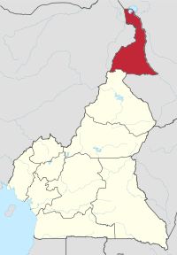
Far North Province within Cameroon
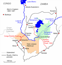
A map of the Congo Pedicle
Cibitoke Province, Burundi
Far North Region, Cameroon
Congo Pedicle, Democratic Republic of the Congo
Kongo Central, Democratic Republic of the Congo
Southern Red Sea Region, Eritrea
Gambela Region, Ethiopia
Nimba County, Liberia
Nsanje District, Malawi
Kayes Region, Mali
Azawad, Mali
Tete Province, Mozambique
Caprivi Strip, Namibia
Casamance, Senegal
Kalahari Gemsbok National Park, South Africa
Blue Nile, Sudan
Wadi Halfa Salient, Sudan
Kagera Region, Tanzania
Americas

Misiones Province within Argentina
Misiones, Argentina
Roraima, Brazil- Southeast Ontario, Canada
Tatshenshini-Alsek Park[clarification needed], British Columbia, Canada- Amazon Trapezium, Amazonas, Colombia
- Southeast Guainía Department, Colombia
Yavarate, Vaupés Department, Colombia
Petén, Guatemala
Tumbes Region, Peru
Southeast Alaska, Alaska, United States (see also Panhandles in the United States)
Amazonas, Venezuela
Asia

Map of India showing the Seven Sister states in the northeast plus the smaller salient of Sikkim immediately to their west.

The 14 provinces of Thailand forming the salient of Southern Thailand.
Wakhan Corridor, Afghanistan
Chittagong, Bangladesh
Rangpur, Bangladesh
Tanintharyi Region, Burma (Myanmar)
Parrot's Beak, Cambodia
Louroujina Salient, Cyprus
Seven Sister States, India (largest in the world)
Sikkim, India
Jerusalem corridor, Israel
Galilee Panhandle, Israel
Mafraq Governorate, Jordan
Mangystau Region, Kazakhstan
Batken, Kyrgyzstan
Phongsaly Province, Laos
North Hamgyŏng, South Hamgyŏng, and Ryanggang, together comprise the "panhandle" of North Korea[citation needed][who?]
Primorsky Krai, Russia
Sughd, Tajikistan
Southern Thailand, Thailand
Hatay Province, Turkey
Surxondaryo Region, Uzbekistan
Tây Ninh Province, Vietnam
Europe

Dutch Limburg shown within the Netherlands
Syunik, Armenia
Tyrol and Vorarlberg together comprise the western "panhandle" of Austria
West-Flanders, Belgium
Neum, Bosnia and Herzegovina
Vidin Province, Bulgaria
Dubrovnik-Neretva County, Croatia
Cheb District, Czech Republic
Šluknov Hook, Czech Republic
Laatre, Viljandi County, Estonia
Enontekiö, Finland
Charleville-Mézières, France
Kakheti, Georgia
Western Thrace, Greece
Donegal, Ireland
Monaghan, Ireland
Province of Trieste, Italy
Dieveniškės Appendix, Lithuania
Briceni District, Moldova
Castelré, Noord-Brabant, the Netherlands
Limburg, the Netherlands
Bogatynia, Poland
Bryansk Oblast, Russia
Galicia, Spain
Canton of Geneva, Switzerland
Canton of Schaffhausen, Switzerland
Bernina, Inn, Lugano, Mendrisio and Porrentruy Districts, Switzerland
Budjak, Ukraine
Subnational salients
The following locations are salients in First-level administrative subdivisions of nations.
Subnational salients in Africa

Location of Cuvette Department within the Republic of the Congo. The southwestern arm is Okoyo District. The Kimongo District salient, in Niari Department, can also be clearly seen in the country's southwest.
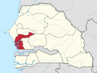
Location of the Fatick Region within Senegal. Gossas Departement is the northeastern arm.
Tafraoui, Oran Province, Algeria- Southwestern Saïda Province, Algeria
- Northeastern Bié Province, Angola
- Eastern Kgalagadi District, Botswana
Balé Province, Boucle du Mouhoun Region, Burkina Faso
Kouritenga Province, Centre-Est Region, Burkina Faso- Northwest Bujumbura Rural Province, Burundi
- Northern Muyinga Province, Burundi
Okoyo District, Cuvette Department, Republic of the Congo
Kimongo District, Niari Department, Republic of the Congo- Northwestern Wele-Nzas Province, Equatorial Guinea
Sitti Zone, Somali Region, Ethiopia
Haut-Komo Department, Woleu-Ntem Province, Gabon
Upper Denkyira West District, Central Region, Ghana
Télimélé Prefecture, Kindia Region, Guinea- Northeast Mamou Prefecture, Mamou Region, Guinea
- Western Isiolo County, Kenya
- Eastern Al Wahat District, Libya
- Southern Mzimba District, Northern Region, Malawi
- Eastern Dakhlet Nouadhibou Region, Mauritania
Boumdeid Department, Assaba Region, Mauritania- Southeastern Tete Province, Mozambique
Gossas Department, Fatick Region, Senegal- Southern Uvinza District, Kigoma Region, Tanzania
Babati, Hanang, and Mbulu Districts, Manyara Region, Tanzania
Gokwe North and Gokwe South Districts, Midlands Province, Zimbabwe
Subnational salients in the Americas

Guayas Province, Ecuador. Balzar and El Empalme Cantons form the northern arm of the province.

Venezuela's Barinas State. Andrés Eloy Blanco is the small western extension of the state, Arismendi is the larger eastern extremity. Páez, in Apure, lies immediately to the south of western Barinas.
- Southern Buenos Aires Province, Argentina
Luis Calvo, Chuquisaca Department, Bolivia
Sud Cinti, Chuquisaca Department, Bolivia
Whale Coast, Bahia, Brazil- Northern Mato Grosso, Brazil
Triângulo Mineiro, Minas Gerais, Brazil- Northwestern British Columbia, Canada
Arauco Province, Bío Bío Region, Chile
San Antonio Province, Valparaíso Region, Chile
Santander Department northern tip, Colombia- Southeastern Cauca Department, Colombia
Urabá region, Antioquia Department, Colombia- Western Puntarenas Province, Costa Rica
Guamá, Santiago de Cuba Province, Cuba- Southern Hato Mayor Province, Dominican Republic
- Southern Samaná Province, Dominican Republic
Cotacachi Canton, Imbabura Province, Ecuador- Southeastern Napo Province, Ecuador
Balzar and El Empalme Cantons, Guayas Province, Ecuador- Southern San Miguel Department, El Salvador
- Northern East Berbice-Corentyne, Guyana
Norte, Jalisco, Mexico- Eastern Tabasco, Mexico
- Southeastern Zacatecas, Mexico
- Southern Zacatecas, Mexico
Chiriquí Grande District, Bocas del Toro Province, Panama- Southern Chimán District, Panamá Province, Panama
Mariato District, Veraguas Province, Panama- Northern Tapanahony, Sipaliwini District, Suriname
Páez, Apure, Venezuela- Western Andrés Eloy Blanco Municipality, Barinas, Venezuela
Arismendi Municipality, Barinas, Venezuela
Panhandles in the United States

Locations of panhandles within states of the USA
| State | Largest city | Population | Area (sq mi) | Area (km2) | Population density (per sq mi) | Population density (/km2) |
|---|---|---|---|---|---|---|
| Alaska | Juneau | 71,616 | 35,138 | 91,010 | 2 | 0.77 |
| Connecticut | Stamford | 224,284 | 96 | 250 | 2,336 | 902 |
Florida* | Tallahassee | 1,407,925 | 11,304 | 29,280 | 125 | 48 |
| Idaho | Coeur d'Alene | 317,751 | 21,013 | 54,420 | 15 | 5.8 |
Maryland† | Frederick | 492,950 | 2,194 | 5,680 | 225 | 87 |
| Nebraska | Scottsbluff | 87,789 | 14,258 | 36,930 | 6 | 2.3 |
| Oklahoma | Guymon | 28,751 | 5,687 | 14,730 | 5 | 1.9 |
| Texas | Amarillo | 427,927 | 25,887 | 67,050 | 17 | 6.6 |
| Eastern West Virginia | Martinsburg | 261,041 | 3,499 | 9,060 | 75 | 29 |
| Northern West Virginia | Wheeling | 132,295 | 601 | 1,560 | 220 | 85 |
* This definition includes the following counties: Bay, Calhoun, Escambia, Franklin, Gadsden, Gulf, Holmes, Jackson, Jefferson, Leon, Liberty, Madison, Okaloosa, Santa Rosa, Taylor, Wakulla, Walton, and Washington.
† This definition includes the following counties: Allegany, Frederick, Garrett, and Washington
Many people in the Pacific Northwest refer to the extreme northern section of Idaho's panhandle as "The Chimney", due to its resemblance to a chimney when viewed on maps.[citation needed]
Although Utah, like Nebraska, has a protrusion from its otherwise straight border, it is not usually considered a panhandle, as half of the Salt Lake City metropolitan area, the most populous region in the state and the home of the state's capital, is located in the region. Likewise, though New York has a southern protrusion that is more conspicuous than e.g. the Connecticut, Texas and Nebraska Panhandles, this is never considered a panhandle since it accommodates the most densely populated parts of the state. (In New York's case, its irregular shape leaves certain regions up for debate. From a different perspective, that region is part of the New York mainland while a western salient juts out.) Thus, the concept of a panhandle may not be purely geographic but may also have a demographic component.
- The six northwest Cook County, Illinois townships, outside of Chicago.[1]
- The Pittsburgh, Cincinnati, Chicago and St. Louis Railway was often called the Panhandle, as it crossed the Northern Panhandle of West Virginia.
- The San Francisco Panhandle, California
- Northern part of Lancaster County, South Carolina
Subnational salients in Asia

Location of Nabatieh District within Nabatieh Governorate, Lebanon.

Map of Gorno-Badakhshan within Tajikistan, showing the panhandle of Darvoz District in the west.
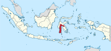
South Sulawesi in Indonesia, with a panhandle of East Luwu Regency in the east
Wakhan District, Badakhshan Province, Afghanistan
Nawa District, Ghazni Province, Afghanistan
Chishti Sharif District, Herat Province, Afghanistan- Eastern Sarpang District, Bhutan
- Northern Mandalay Division, Burma
- Eastern Chuzhou, Anhui, China PR
- Western Gannan Tibetan Autonomous Prefecture, Gansu, China PR
Jiuquan, Pingliang and Qingyang, Gansu, China PR
Daxing'anling Prefecture, Heilongjiang, China PR
Zhaotong, Yunnan, China PR
Koraput and Malkangiri districts, Odisha, India
Kota division, Rajasthan, India- Southern Jhansi division, Uttar Pradesh, India
East Luwu Regency, South Sulawesi, Indonesia
Pasaman Regency, West Sumatra, Indonesia
Semirom County, Isfahan Province, Iran- Southwest Razavi Khorasan Province, Iran
- Southern Yazd Province, Iran
Wadi Araba Department, Aqaba Governorate, Jordan
Russeifa Department, Zarqa Governorate, Jordan- Southwest Panfilov District, Chuy Region, Kyrgyzstan
Chong-Alay District, Osh Region, Kyrgyzstan
Nabatieh District, Nabatieh Governorate, Lebanon- Eastern Achham District, Far-Western Region, Nepal
- Western Surkhet District, Mid-Western Region, Nepal
Bannu, Karak, and Kohat Divisions, Khyber Pakhtunkhwa, Pakistan- Eastern Maguindanao, Philippines
Makati City, Philippines
Trincomalee District, Eastern Province, Sri Lanka
Al-Suqaylabiyah District, Hama Governorate, Syria
Darvoz District, Gorno-Badakhshan Autonomous Region, Tajikistan- Western Dhamar Governorate, Yemen
South Jakarta, Jakarta Special Capital Region, and Depok, West Java, Indonesia.
Subnational salients in Europe

Location of Newmarket (shown as red dot) within Suffolk, England.
- Southern Gmunden, Upper Austria, Austria
Frederikshavn Municipality, North Denmark Region, Denmark
Parikkala, South Karelia, Finland
Ruokolahti, South Karelia, Finland
Varkaus, Pohjois-Savo, Finland
Lower Franconia, Bavaria, Germany
Osnabrück District and City, Lower Saxony, Germany
Altenburger Land, Thuringia, Germany- Northern Pest County, Hungary
- Clonlisk, County Offaly, Leinster, Ireland
Province of Rieti, Lazio, Italy
Raseiniai District Municipality, Kaunas County, Lithuania
Rivierenland, Gelderland, the Netherlands
Steenwijkerland, Overijssel, the Netherlands
Mourão, Évora District, Portugal
Vorkuta District, Komi Republic, Russia
Diessenhofen, Schlatt bei Diessenhofen, and Basadingen-Schlattingen, Frauenfeld District, Thurgau, Switzerland
Monthey District, Valais, Switzerland
Buckfastleigh, Teignbridge, United Kingdom
Ceiriog Valley, Wrexham County Borough, Wales, United Kingdom- Western New Forest District, Hampshire, United Kingdom
Newmarket, Suffolk, United Kingdom
North Cornwall, Cornwall, United Kingdom
South Staffordshire, Staffordshire, United Kingdom- The area around Tring, Hertfordshire, United Kingdom
Subnational salients in Oceania

Location of Anetan District within Nauru.
- Northeastern Nadroga-Navosa Province, Western Division, Fiji
- Southern Anetan District, Nauru
Rangitaiki River Valley, Bay of Plenty Region, New Zealand
Hunter River Valley, Otago region, New Zealand- Northeastern West New Britain Province, Papua New Guinea
See also
- Bootheel
- Border irregularities of the United States
- Border
- Chicken's Neck (disambiguation)
- Corridor (disambiguation)
- Enclave and exclave
Fergana Valley (triple junction of Uzbekistan, Kyrgyzstan and Tajikistan)- Gerrymandering
- Political geography
- Salients, re-entrants and pockets
- The Thumb
References
^ "Cook County Forest Preserve District Recreational Facilities". Users.rcn.com. Retrieved 2012-11-15..mw-parser-output cite.citation{font-style:inherit}.mw-parser-output .citation q{quotes:"""""""'""'"}.mw-parser-output .citation .cs1-lock-free a{background:url("//upload.wikimedia.org/wikipedia/commons/thumb/6/65/Lock-green.svg/9px-Lock-green.svg.png")no-repeat;background-position:right .1em center}.mw-parser-output .citation .cs1-lock-limited a,.mw-parser-output .citation .cs1-lock-registration a{background:url("//upload.wikimedia.org/wikipedia/commons/thumb/d/d6/Lock-gray-alt-2.svg/9px-Lock-gray-alt-2.svg.png")no-repeat;background-position:right .1em center}.mw-parser-output .citation .cs1-lock-subscription a{background:url("//upload.wikimedia.org/wikipedia/commons/thumb/a/aa/Lock-red-alt-2.svg/9px-Lock-red-alt-2.svg.png")no-repeat;background-position:right .1em center}.mw-parser-output .cs1-subscription,.mw-parser-output .cs1-registration{color:#555}.mw-parser-output .cs1-subscription span,.mw-parser-output .cs1-registration span{border-bottom:1px dotted;cursor:help}.mw-parser-output .cs1-ws-icon a{background:url("//upload.wikimedia.org/wikipedia/commons/thumb/4/4c/Wikisource-logo.svg/12px-Wikisource-logo.svg.png")no-repeat;background-position:right .1em center}.mw-parser-output code.cs1-code{color:inherit;background:inherit;border:inherit;padding:inherit}.mw-parser-output .cs1-hidden-error{display:none;font-size:100%}.mw-parser-output .cs1-visible-error{font-size:100%}.mw-parser-output .cs1-maint{display:none;color:#33aa33;margin-left:0.3em}.mw-parser-output .cs1-subscription,.mw-parser-output .cs1-registration,.mw-parser-output .cs1-format{font-size:95%}.mw-parser-output .cs1-kern-left,.mw-parser-output .cs1-kern-wl-left{padding-left:0.2em}.mw-parser-output .cs1-kern-right,.mw-parser-output .cs1-kern-wl-right{padding-right:0.2em}


