Ben Shemen
Ben Shemen .mw-parser-output .script-hebrew,.mw-parser-output .script-Hebr{font-size:1.15em;font-family:"Ezra SIL","Ezra SIL SR","Keter Aram Tsova","Taamey Ashkenaz","Taamey David CLM","Taamey Frank CLM","Frank Ruehl CLM","Keter YG","Shofar","David CLM","Hadasim CLM","Simple CLM","Nachlieli","SBL BibLit","SBL Hebrew",Cardo,Alef,"Noto Serif Hebrew","Noto Sans Hebrew","David Libre",David,"Times New Roman",Gisha,Arial,FreeSerif,FreeSans} בֶּן שֶׁמֶן | |
|---|---|
 | |
 Ben Shemen | |
| Coordinates: 31°57′14.4″N 34°55′29.64″E / 31.954000°N 34.9249000°E / 31.954000; 34.9249000Coordinates: 31°57′14.4″N 34°55′29.64″E / 31.954000°N 34.9249000°E / 31.954000; 34.9249000 | |
| District | Central |
| Council | Hevel Modi'in |
| Affiliation | Moshavim Movement |
| Founded | 1905 (original) 1952 (re-establishment) |
| Population (2017)[1] | 862 |

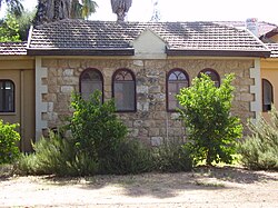
Bezalel workshop at Ben Shemen, 1911
Ben Shemen (Hebrew: בֶּן שֶׁמֶן) is a moshav in central Israel. Located around four kilometres east of Lod, it falls under the jurisdiction of Hevel Modi'in Regional Council. In 2017 it had a population of 862.[1]
Contents
1 Etymology
2 History
3 Notable residents
4 See also
5 References
6 External links
Etymology
The village's name is taken from Isaiah 5:1;
Let me sing of my well-beloved, a song of my beloved touching his vineyard. My well-beloved had a vineyard in a very fruitful hill.[2]
and also reflects the JNF's planting of olive trees in this area.[3]
History
The moshav was founded in 1905, and was one of the first villages established on Jewish National Fund land;[3] the first Jewish National Fund forest is also located in Ben Shemen.[3]
According to a census conducted in 1922 by the British Mandate authorities, Ben Shemen had a population of 90 Jews.[4] Which had increased in the 1931 census to 353 residents, in 30 houses.[5]
In 1923 it was split in two, with a group of trial farms eventually becoming a separate moshav, Kerem Ben Shemen.
The Ben Shemen Youth Village was established adjacent to the moshav in 1927 and is today a large agricultural boarding school.[6][3]
During World War II, Ben Shemen was the site of a British search for weapons. Similar searches were a common British response to Jewish opposition to the White Paper of 1939.[7] In 1947 Ben Shemen had a population of 75.[3] The village experienced extensive damage during the early days of the 1948 Arab–Israeli war and had to be reconstructed.[3]Immigrants from Romania joined the moshav in 1952. Some houses were built by Bezalel Academy of Art and Design founder Boris Schatz.

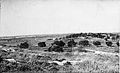
Ben Shemen 1948. Photograph from Palmach archive
Ben Shemen. 1948. Used as a base by the Yiftach Brigade

Ben Shemen 1948. Dining room
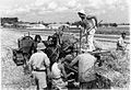
Ben Shemen. Harvest
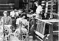
Ben Shemen. Processing wool
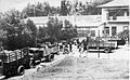
Ben Shemen being evacuated in early 1948


Notable residents
- Benjamin Elazari Volcani
- Aharon Yadlin
See also
- Ben Shemen Interchange
References
^ ab "List of localities, in Alphabetical order" (PDF). Israel Central Bureau of Statistics. Retrieved August 26, 2018..mw-parser-output cite.citation{font-style:inherit}.mw-parser-output .citation q{quotes:"""""""'""'"}.mw-parser-output .citation .cs1-lock-free a{background:url("//upload.wikimedia.org/wikipedia/commons/thumb/6/65/Lock-green.svg/9px-Lock-green.svg.png")no-repeat;background-position:right .1em center}.mw-parser-output .citation .cs1-lock-limited a,.mw-parser-output .citation .cs1-lock-registration a{background:url("//upload.wikimedia.org/wikipedia/commons/thumb/d/d6/Lock-gray-alt-2.svg/9px-Lock-gray-alt-2.svg.png")no-repeat;background-position:right .1em center}.mw-parser-output .citation .cs1-lock-subscription a{background:url("//upload.wikimedia.org/wikipedia/commons/thumb/a/aa/Lock-red-alt-2.svg/9px-Lock-red-alt-2.svg.png")no-repeat;background-position:right .1em center}.mw-parser-output .cs1-subscription,.mw-parser-output .cs1-registration{color:#555}.mw-parser-output .cs1-subscription span,.mw-parser-output .cs1-registration span{border-bottom:1px dotted;cursor:help}.mw-parser-output .cs1-ws-icon a{background:url("//upload.wikimedia.org/wikipedia/commons/thumb/4/4c/Wikisource-logo.svg/12px-Wikisource-logo.svg.png")no-repeat;background-position:right .1em center}.mw-parser-output code.cs1-code{color:inherit;background:inherit;border:inherit;padding:inherit}.mw-parser-output .cs1-hidden-error{display:none;font-size:100%}.mw-parser-output .cs1-visible-error{font-size:100%}.mw-parser-output .cs1-maint{display:none;color:#33aa33;margin-left:0.3em}.mw-parser-output .cs1-subscription,.mw-parser-output .cs1-registration,.mw-parser-output .cs1-format{font-size:95%}.mw-parser-output .cs1-kern-left,.mw-parser-output .cs1-kern-wl-left{padding-left:0.2em}.mw-parser-output .cs1-kern-right,.mw-parser-output .cs1-kern-wl-right{padding-right:0.2em}
^ Isaiah Chapter 5 Mechon Mamre
^ abcdef Jewish National Fund (1949). Jewish Villages in Israel. Jerusalem: Hamadpis Liphshitz Press. p. 16.
^ [1]
^ Mills, 1932, p. 19
^ Chaya H. Roth (16 September 2008). The fate of Holocaust memories: transmission and family dialogues. Macmillan. pp. 83–. ISBN 978-0-230-60607-4. Retrieved 10 April 2011.
^ Anita, Shapira (1992). Land and Power, The Zionist Resort to Force. Chapter 7: Oxford University Press. p. 288.
External links
Ben Shemen, Cross-Israel Highway: Reproduction of an oil press Israel Antiquities Authority


