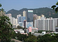
Kwai Chung
| Kwai Chung | |||||||||||||||||
 Kwai Chung skyline in 2010 | |||||||||||||||||
| Traditional Chinese | 葵涌 | ||||||||||||||||
|---|---|---|---|---|---|---|---|---|---|---|---|---|---|---|---|---|---|
| |||||||||||||||||

Constituencies in 2003 District Council Election. Kwai Chung is the region on the right.
Kwai Chung is an urban area within Tsuen Wan New Town in the New Territories of Hong Kong. Together with Tsing Yi Island, it is part of the Kwai Tsing District District of Hong Kong. Kwai Chung is the site of the container port. It is also part of Tsuen Wan New Town. In 2000, it had a population of 287,000. Its area is 9.93 km². Areas within Kwai Chung include: Kwai Fong, Kwai Hing, Lai King, Tai Wo Hau.
Contents
1 Origin of the name
2 Divisions
3 Economy
4 See also
5 External links
Origin of the name
In earlier times Kwai Chung was called Kwai Chung Tsz (葵涌子). Kwai Chung was a stream (Chung) that emptied into Gin Drinkers Bay. The whole bay was reclaimed for land and the stream is no longer visible.
Divisions
Traditionally, Kwai Chung is divided into Upper Kwai Chung or Sheung Kwai Chung (上葵涌), and Lower Kwai Chung or Ha Kwai Chung (下葵涌). Administratively, the former is called North Kwai Chung, and the latter South Kwai Chung.
Economy
Kwai Chung is the home of the principal commercial cargo handling area of Hong Kong, the Kwai Chung Container Terminal, one of the largest and busiest port facilities in the world. The main commercial port was relocated here from Yau Ma Tei in the 1980s, in preparation for the West Kowloon Reclamation, which has left the original waterfront of Yau Ma Tei almost half a mile inland.
See also
- List of areas of Hong Kong
- Public housing estates in Kwai Chung
Hulu Concept, a not-for-profit cultural organisation based in Kwai Chung
External links
| Wikimedia Commons has media related to Kwai Chung. |
- Satellite view of the container port in Kwai Chung
Coordinates: 22°22′0″N 114°7′30″E / 22.36667°N 114.12500°E / 22.36667; 114.12500