Stepantsminda
Stepantsminda სტეფანწმინდა | |
|---|---|
Townlet | |
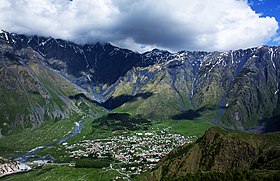 View on Stepantsminda | |
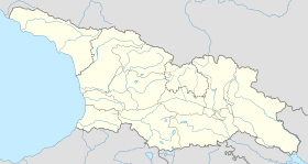 Stepantsminda Location of Stepantsminda in Georgia Show map of Georgia  Stepantsminda Stepantsminda (Mtskheta-Mtianeti) Show map of Mtskheta-Mtianeti | |
| Coordinates: 42°39′27″N 44°38′43″E / 42.65750°N 44.64528°E / 42.65750; 44.64528Coordinates: 42°39′27″N 44°38′43″E / 42.65750°N 44.64528°E / 42.65750; 44.64528 | |
| Country | |
| Mkhare | Mtskheta-Mtianeti |
| Municipality | Kazbegi |
| Elevation | 1,740 m (5,710 ft) |
| Population (2014)[1] | |
| • Total | 1,326 |
| Time zone | UTC+4 (Georgian Time) |
Stepantsminda (Georgian: სტეფანწმინდა; formerly Kazbegi, ყაზბეგი), is a townlet in the Mtskheta-Mtianeti region of north-eastern Georgia. Historically and ethnographically, the town is part of the Khevi province. It is the center of the Kazbegi Municipality.
Contents
1 Etymology
2 Geography and climate
3 History
4 Attractions and sport facilities
5 Landmarks
6 Border crossing point to Russia
7 Infrastructure
8 See also
9 References
10 External links
Etymology
Stepantsminda was named after a Georgian Orthodox monk named Stephan, who constructed a hermitage at this location on what later became the Georgian Military Road.
Geography and climate
The town is located along the banks of the Terek River, 157 kilometers (98 mi) to the north of Tbilisi at an elevation of 1,740 meters (5,710 feet) above sea level. Stepantsminda’s climate is moderately humid with relatively dry, cold winters and long and cool summers. The average annual temperature is 4.9 degrees Celsius. January is the coldest month with an average temperature of -5.2 degrees Celsius while July is the warmest month with an average temperature of 14.4 degrees Celsius. The absolute minimum recorded temperature is -34 degrees Celsius and the absolute maximum is 32 degrees Celsius. Stepantsminda’s average annual precipitation is 790 mm. (31.1 inches). The town is dominated by large mountains on all sides. The most notable mountain of the region, Mount Kazbek, lies immediately to the west of town. The second most prominent peak, Mt. Shani, rises to an elevation of 4,451 meters (14,600 feet) above sea level, 9 kilometers to the east of Stepantsminda. The town is located 10 kilometers to the south of the famous Darial Gorge.
History

The Gergeti Trinity Church, the main cultural landmark of Stepantsminda.
According to tradition, Stepantsminda, literally "Saint Stephan", was named so after a Georgian Orthodox monk Stephan, who constructed a hermitage at this location on what later became the Georgian Military Highway. It came under the control of a local feudal magnate, the Chopikashvili clan, who were in charge of collecting tolls on travelers in the area in the late 18th century. After the expansion of the Russian Empire into the Kingdom of Georgia in the early 19th century, the people of the region revolted against Russian rule. However, the local lord Gabriel Chopikashvili, son of Kazi-Beg, remained steadfast in his loyalty to Russia and helped to suppress the revolt. In return, he was promoted to officer in the Russian Army. He adopted the surname Kazbegi, and the village under his control was also frequently referred to as "Kazbegi". The name was officially changed to Kazbegi under Soviet rule in 1925. Gabriel Chopikashvili-Kazbegi's grandson was the famed Georgian writer Alexander Kazbegi, who was born in this town. In 2006, the town reverted to its original name of Stepantsminda.
Attractions and sport facilities

Stepantsminda along with Kuro and Shino glaciers
- Horse-riding
- Paragliding
- Bike-riding
- Gergeti Sameba Church
- Natural mineral waters
- Mount Kazbek climbing
- Glaciers

Stepantsminda from MKinvartsveri (Kazbek) slope.
Landmarks
Stepantsiminda is known for its scenic location in the Greater Caucasus mountains, and is a center for trekkers and mountain climbing. Local attractions include the Kazbegi Museum and Ethnographic Museum in town, and the Gergeti Trinity Church outside of town, as well as Mount Kazbegi itself and the alpine meadows and forests of the surrounding Kazbegi Nature Reserve.

Border crossing point to Russia

Georgian part of the border crossing point.
There is Georgian border crossing point "Larsi" to the Russian Federation approximately 12 kilometers to the North. The crossing was opened on 1st March 2010.
During winter (1 November - 28 February), it is open daily from 7AM till 7PM, and during summer (1 March - 31 October) from 6AM till 10PM. The customs is multilateral, for all citizens of the world. The cross-border road is in a mountain tunnel. It is not possible to cross the border on foot.
Infrastructure
In December, 2016 it was announced that AGH holding company plans to build an international airport in Stepantsminda. AGH founded "Aviator" company will provide Air Taxi service that will comprise individual charter flights to any airports in Georgia as well as to neighbouring countries.[2]
See also
- Mtskheta-Mtianeti
References
^ "Population Census 2014". www.geostat.ge. National Statistics Office of Georgia. November 2014. Retrieved 2 June 2016..mw-parser-output cite.citation{font-style:inherit}.mw-parser-output .citation q{quotes:"""""""'""'"}.mw-parser-output .citation .cs1-lock-free a{background:url("//upload.wikimedia.org/wikipedia/commons/thumb/6/65/Lock-green.svg/9px-Lock-green.svg.png")no-repeat;background-position:right .1em center}.mw-parser-output .citation .cs1-lock-limited a,.mw-parser-output .citation .cs1-lock-registration a{background:url("//upload.wikimedia.org/wikipedia/commons/thumb/d/d6/Lock-gray-alt-2.svg/9px-Lock-gray-alt-2.svg.png")no-repeat;background-position:right .1em center}.mw-parser-output .citation .cs1-lock-subscription a{background:url("//upload.wikimedia.org/wikipedia/commons/thumb/a/aa/Lock-red-alt-2.svg/9px-Lock-red-alt-2.svg.png")no-repeat;background-position:right .1em center}.mw-parser-output .cs1-subscription,.mw-parser-output .cs1-registration{color:#555}.mw-parser-output .cs1-subscription span,.mw-parser-output .cs1-registration span{border-bottom:1px dotted;cursor:help}.mw-parser-output .cs1-ws-icon a{background:url("//upload.wikimedia.org/wikipedia/commons/thumb/4/4c/Wikisource-logo.svg/12px-Wikisource-logo.svg.png")no-repeat;background-position:right .1em center}.mw-parser-output code.cs1-code{color:inherit;background:inherit;border:inherit;padding:inherit}.mw-parser-output .cs1-hidden-error{display:none;font-size:100%}.mw-parser-output .cs1-visible-error{font-size:100%}.mw-parser-output .cs1-maint{display:none;color:#33aa33;margin-left:0.3em}.mw-parser-output .cs1-subscription,.mw-parser-output .cs1-registration,.mw-parser-output .cs1-format{font-size:95%}.mw-parser-output .cs1-kern-left,.mw-parser-output .cs1-kern-wl-left{padding-left:0.2em}.mw-parser-output .cs1-kern-right,.mw-parser-output .cs1-kern-wl-right{padding-right:0.2em}
^ Charkviani, Nikoloz (13 December 2016). "Adjara Group to Build an International Airport in Kazbegi and Invest More in Aviation". The Financial. Retrieved 15 December 2016.
- "Kazbegi." Georgian Soviet Encyclopedia. Vol. 10, Tbilisi, 1984, pp. 617
- Rosen, Roger. Georgia: A Sovereign Country of the Caucasus. Odyssey Publications: Hong Kong, 1999.
ISBN 962-217-748-4
External links
| Wikimedia Commons has media related to Stepantsminda. |
| Wikivoyage has a travel guide for Stepantsminda. |
Kazbegi Municipality. Mtskheta-Mtianeti Regional Administration website.
Cities, towns and townlets in Georgia | ||
|---|---|---|
| Autonomous Republic of Abkhazia |
|   |
| Autonomous Republic of Adjara |
| |
| Guria |
| |
| Imereti |
| |
| Kakheti |
| |
| Mtskheta-Mtianeti |
| |
| Samegrelo-Zemo Svaneti |
| |
| Samtskhe-Javakheti |
| |
| Racha-Lechkhumi and Kvemo Svaneti |
| |
| Kvemo Kartli |
| |
| Shida Kartli |
| |
| Cities with local government |
| |
| Capital city |
| |


