Tumaco
This article may be expanded with text translated from the corresponding article in Spanish. (October 2012) Click [show] for important translation instructions.
|
San Andrés de Tumaco | |||
|---|---|---|---|
 El Bajito beach | |||
| |||
| Motto(s): The Most Educated One of the Pacific | |||
 Location of the city (red) and municipality (dark gray) of Tumaco in the Nariño Department. | |||
 San Andrés de Tumaco Location of the city (red) and municipality (dark gray) of Tumaco in the Nariño Department. | |||
| Coordinates: 1°48′24″N 78°45′53″W / 1.80667°N 78.76472°W / 1.80667; -78.76472Coordinates: 1°48′24″N 78°45′53″W / 1.80667°N 78.76472°W / 1.80667; -78.76472 | |||
| Country | Colombia | ||
| Department | Nariño Department | ||
| Founded | 1640 | ||
| Government | |||
| • Mayor | María Emilsen Angulo Guevara | ||
| Area | |||
| • Total | 3,760 km2 (1,450 sq mi) | ||
| Elevation | 2 m (7 ft) | ||
| Population (2016) | |||
| • Total | 203,971 | ||
| • Density | 54/km2 (140/sq mi) | ||
| Demonym(s) | Tumaqueño | ||
| Time zone | UTC-5 | ||
| Area code(s) | 57 + 2 | ||
| Website | Official website (in Spanish) | ||


Tumaco is a port city and municipality in the Nariño Department, Colombia, by the Pacific Ocean. It is located on the southwestern corner of Colombia, near the border with Ecuador, and enjoys of hot tropical climate. Tumaco is inhabited mainly by Afro-Colombians and some indigenous people.
Tumaco is accessible by plane, from the western city of Cali, one of the main urban centers of the country, well connected to Bogotá, the capital city. It can also be reached by land via highway from the city of Pasto, the capital city of the Nariño Department. Tumaco is known for being the hometown of many great Colombian soccer players, including Willington Ortiz.
Colombian film director Samuel Córdoba released a documentary about the city in 2009. The film, entitled "Tumaco Pacífico",[1] chronicles the stilt-house area of the city, predominantly populated by Afro-Colombians. Córdoba was inspired by a panoramic photo of the stilt houses he saw in a photography book on Tumaco. The film won first place at the Festival de Cine Latinoamericano de Bordeaux, in France, and was presented at the Festival Internacional de Cine, in Santiago, Chile.
Other places of interest include ecotourism sites and beaches located near the mouth of the Mira River, where the river meets the sea. Also, there are the Playas de Milagros (beaches of Miracles), and Bocananueva y Teran beaches, where visitors can experience the diversity of flora and fauna first-hand.[2]
Contents
1 Image Gallery
2 Climate
3 Economy
4 Transportation
5 Impact of the armed conflict
6 See also
7 References
8 External links
Image Gallery

Tumaco gold figure 1st century BC.
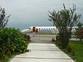
Embraer ERJ 145 at the La Florida (Colombia) airport.
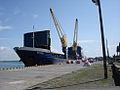
Potosi Merchant vessel unloading fertilizers at the Tumaco port.

Embraer ERJ-170LR at the La Florida (Colombia) airport.

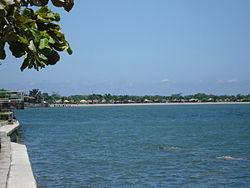
Bajito beach at Tumaco.
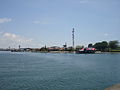
Panoramic view of the Viciosa island at Tumaco.


Climate
Like all of the Colombian Pacific coast, Tumaco has a hot, rainy, overcast and oppressively humid tropical rainforest climate (Köppen Af), although it is less extreme than areas further north, with annual rainfall totalling only around 2,300 millimetres or 90 inches, vis-à-vis 5,750 millimetres (230 in) at Buenaventura and 8,130 millimetres (320 in) at Quibdó. The wettest months are from January to June, and there is a rainfall trough in November opposite to northern Colombia.
| Climate data for Tumaco (Aeropuerto La Florida) | |||||||||||||
|---|---|---|---|---|---|---|---|---|---|---|---|---|---|
| Month | Jan | Feb | Mar | Apr | May | Jun | Jul | Aug | Sep | Oct | Nov | Dec | Year |
| Record high °C (°F) | 34.0 (93.2) | 33.4 (92.1) | 34.4 (93.9) | 34.0 (93.2) | 35.1 (95.2) | 32.2 (90.0) | 32.1 (89.8) | 32.9 (91.2) | 32.2 (90.0) | 36.2 (97.2) | 32.6 (90.7) | 32.6 (90.7) | 36.2 (97.2) |
| Average high °C (°F) | 29.3 (84.7) | 29.6 (85.3) | 29.8 (85.6) | 30.0 (86.0) | 29.6 (85.3) | 29.5 (85.1) | 29.4 (84.9) | 29.1 (84.4) | 29.1 (84.4) | 29.3 (84.7) | 29.1 (84.4) | 29.1 (84.4) | 29.4 (84.9) |
| Average low °C (°F) | 22 (72) | 22.5 (72.5) | 22.7 (72.9) | 22.5 (72.5) | 21.9 (71.4) | 21.9 (71.4) | 21.9 (71.4) | 21.8 (71.2) | 22.3 (72.1) | 21.7 (71.1) | 21.9 (71.4) | 22.0 (71.6) | 22.1 (71.8) |
| Record low °C (°F) | 16.6 (61.9) | 16.0 (60.8) | 17.1 (62.8) | 16.4 (61.5) | 16.0 (60.8) | 16.4 (61.5) | 17.0 (62.6) | 16.6 (61.9) | 17.2 (63.0) | 16.2 (61.2) | 17.0 (62.6) | 16.8 (62.2) | 16.0 (60.8) |
| Average rainfall mm (inches) | 287.0 (11.30) | 230.9 (9.09) | 217.6 (8.57) | 330.9 (13.03) | 308.3 (12.14) | 277.8 (10.94) | 129.6 (5.10) | 111.7 (4.40) | 105.2 (4.14) | 80.9 (3.19) | 73.8 (2.91) | 138.1 (5.44) | 2,291.8 (90.25) |
| Average rainy days | 18 | 14 | 15 | 18 | 21 | 19 | 14 | 13 | 14 | 12 | 9 | 15 | 182 |
| Average relative humidity (%) | 85 | 85 | 84 | 84 | 85 | 86 | 84 | 84 | 85 | 85 | 84 | 86 | 85 |
| Mean monthly sunshine hours | 99.5 | 121.2 | 161.6 | 141.5 | 116.2 | 92.0 | 123.6 | 115.7 | 89.8 | 106.1 | 104.2 | 102.7 | 1,374.1 |
| Source: INSTITUTO DE HIDROLOGIA METEOROLOGIA Y ESTUDIOS AMBIENTALES[3] | |||||||||||||
Economy
Tumaco's location on the coast provides it with a number of maritime-related economic activities. A primary one is
Agricultural production near Tumaco includes dry rice, palm oil and cacao. 35,000 hectares and seven extraction factories are dedicated to the production of palm oil. Family farms also grow cereals.
Tourism has started to take on a more important significance in recent years. The city is nationally known for its music, producing football players, and its beaches.
Transportation
La Florida Airport serves Tumaco with flights from Cali.
Tumaco is the site of Colombia's second most important Pacific port behind Buenaventura. Due to the limited development of roads in the region, the port is the primary way of accessing several villages along the coast.
A paved, 300km long highway connects Tumaco with the departmental capital Pasto.
Impact of the armed conflict
Tumaco was highly affected by the Colombian armed conflict as recently as 2011. On 17 August 2011, four soldiers from the Colombian army were killed in Tumaco by FARC-EP guerrillas from the 29th front.[4] On 29 August 2011 five more soldiers were killed by guerrillas in the outskirts of the city,[5] A few weeks earlier, guerrillas from the Western Bloc of the FARC-EP stormed the local prison, freeing roughly fifteen imprisoned FARC members.[6]
On 26 September, seven people, including a local politician, were killed by unidentified gunmen in the inner city. The perpetrators also kidnapped one politician. Apart from the FARC-EP, the area was the home turf of paramilitary groups like the right-wing Los Rastrojos and the Guevarist, left-wing Ejército de Liberación Nacional.[7] Consequently, Tumaco is bound to benefit greatly from the recent peace treaty with the FARC.
See also
- 1979 Tumaco earthquake
References
^ "Archived copy". Archived from the original on 22 March 2009. Retrieved 23 August 2009.CS1 maint: Archived copy as title (link).mw-parser-output cite.citation{font-style:inherit}.mw-parser-output .citation q{quotes:"""""""'""'"}.mw-parser-output .citation .cs1-lock-free a{background:url("//upload.wikimedia.org/wikipedia/commons/thumb/6/65/Lock-green.svg/9px-Lock-green.svg.png")no-repeat;background-position:right .1em center}.mw-parser-output .citation .cs1-lock-limited a,.mw-parser-output .citation .cs1-lock-registration a{background:url("//upload.wikimedia.org/wikipedia/commons/thumb/d/d6/Lock-gray-alt-2.svg/9px-Lock-gray-alt-2.svg.png")no-repeat;background-position:right .1em center}.mw-parser-output .citation .cs1-lock-subscription a{background:url("//upload.wikimedia.org/wikipedia/commons/thumb/a/aa/Lock-red-alt-2.svg/9px-Lock-red-alt-2.svg.png")no-repeat;background-position:right .1em center}.mw-parser-output .cs1-subscription,.mw-parser-output .cs1-registration{color:#555}.mw-parser-output .cs1-subscription span,.mw-parser-output .cs1-registration span{border-bottom:1px dotted;cursor:help}.mw-parser-output .cs1-ws-icon a{background:url("//upload.wikimedia.org/wikipedia/commons/thumb/4/4c/Wikisource-logo.svg/12px-Wikisource-logo.svg.png")no-repeat;background-position:right .1em center}.mw-parser-output code.cs1-code{color:inherit;background:inherit;border:inherit;padding:inherit}.mw-parser-output .cs1-hidden-error{display:none;font-size:100%}.mw-parser-output .cs1-visible-error{font-size:100%}.mw-parser-output .cs1-maint{display:none;color:#33aa33;margin-left:0.3em}.mw-parser-output .cs1-subscription,.mw-parser-output .cs1-registration,.mw-parser-output .cs1-format{font-size:95%}.mw-parser-output .cs1-kern-left,.mw-parser-output .cs1-kern-wl-left{padding-left:0.2em}.mw-parser-output .cs1-kern-right,.mw-parser-output .cs1-kern-wl-right{padding-right:0.2em}
^ "Archived copy". Archived from the original on 18 December 2014. Retrieved 12 March 2010.CS1 maint: Archived copy as title (link)
^ Clima: Climatografía de la principales ciudades
^ http://www.eltiempo.com/colombia/occidente/ARTICULO-WEB-NEW_NOTA_INTERIOR-10170446.html
^ http://www.elespectador.com/noticias/judicial/articulo-295250-cinco-policias-muertos-ataque-de-farc-tumaco
^ https://www.bbc.co.uk/news/world-latin-america-14101416
^ http://feeds.univision.com/feeds/article/2011-09-26/asesinan-a-siete-personas-entre?refPath=/noticias/ultimas-noticias/ Archived 23 March 2012 at the Wayback Machine
External links
- Tumaco: Tourist guide
- Tumaco: Web Portal San Andres de Tumaco - La Perla Del Pacifico
Municipalities in the Nariño Department | ||
|---|---|---|
| ||
Mining in Colombia | ||
|---|---|---|
| Gold |
|  |
| Silver |
| |
| Platinum |
| |
| Nickel |
| |
| Coltan |
| |
| Emeralds |
| |
| Coal |
| |
| Salt |
| |
| Sources |
| |
Authority control |
|
|---|


