Jiangling County
Jiangling County .mw-parser-output .nobold{font-weight:normal} 江陵县 Kiangling | |
|---|---|
County | |
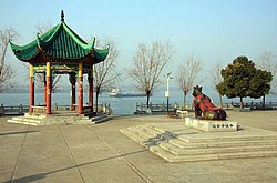
 Jiangling Tieniuji | |
 Jiangling Location in Hubei | |
| Coordinates: 30°08′N 112°30′E / 30.133°N 112.500°E / 30.133; 112.500Coordinates: 30°08′N 112°30′E / 30.133°N 112.500°E / 30.133; 112.500 | |
| Country | People's Republic of China |
| Province | Hubei |
| Prefecture-level city | Jingzhou |
| Population (2010)[1] | |
| • Total | 331,344 |
| Website | www.jiangling.gov.cn |
Jiangling (Chinese: 江陵; pinyin: Jiānglíng; Wade–Giles: Chiang-ling) is a county in southern Hubei province, People's Republic of China. Administratively, it is under the jurisdiction of Jingzhou City.
Contents
1 History
2 Administrative divisions
3 References
4 External links
History
Under the Tang dynasty, it served as the southern capital and was known as Nandu (南都; 'south capital').[2]
Later on, Jiangling was the capital of the small Jingnan kingdom that existed from 924 to 963 during the Five Dynasties and Ten Kingdoms period.[3]
Until 1994, the county also included much of the urban area of Jingzhou City, which was historically also known as "Jiangling".[4]
Administrative divisions
Six towns:[1][5][6]
Zishi (资市镇), Xionghe (熊河镇), Baimasi (白马寺镇), Shagang (沙岗镇), Puji (普济镇), Haoxue (郝穴镇)
Two townships:
Majiazhai Township (马家寨乡), Qinshi Township (秦市乡)
Three other areas:
Jiangbei (江北监狱), Sanhu (三湖农场), Lu/Liuheyuan (六合垸农场)
References
^ ab 江陵县历史沿革 [Jiangling County Historical Development]. 行政区划网站 www.xzqh.org (in Chinese). 行政区划网站/区划地名网站 (Administrative Divisions Web/District Geographic Names Web). 6 August 2014. Retrieved 13 July 2018.2010年第六次人口普查,江陵县常住总人口331344人,其中:资市镇22261人,滩桥镇21788人,熊河镇38689人,白马寺镇41470人,沙岗镇40336人,普济镇31729人,郝穴镇44100人,马家寨乡35400人,秦市乡23067人,江北监狱11369人,三湖管理区12457人,六合垸管理区8678人。
.mw-parser-output cite.citation{font-style:inherit}.mw-parser-output .citation q{quotes:"""""""'""'"}.mw-parser-output .citation .cs1-lock-free a{background:url("//upload.wikimedia.org/wikipedia/commons/thumb/6/65/Lock-green.svg/9px-Lock-green.svg.png")no-repeat;background-position:right .1em center}.mw-parser-output .citation .cs1-lock-limited a,.mw-parser-output .citation .cs1-lock-registration a{background:url("//upload.wikimedia.org/wikipedia/commons/thumb/d/d6/Lock-gray-alt-2.svg/9px-Lock-gray-alt-2.svg.png")no-repeat;background-position:right .1em center}.mw-parser-output .citation .cs1-lock-subscription a{background:url("//upload.wikimedia.org/wikipedia/commons/thumb/a/aa/Lock-red-alt-2.svg/9px-Lock-red-alt-2.svg.png")no-repeat;background-position:right .1em center}.mw-parser-output .cs1-subscription,.mw-parser-output .cs1-registration{color:#555}.mw-parser-output .cs1-subscription span,.mw-parser-output .cs1-registration span{border-bottom:1px dotted;cursor:help}.mw-parser-output .cs1-ws-icon a{background:url("//upload.wikimedia.org/wikipedia/commons/thumb/4/4c/Wikisource-logo.svg/12px-Wikisource-logo.svg.png")no-repeat;background-position:right .1em center}.mw-parser-output code.cs1-code{color:inherit;background:inherit;border:inherit;padding:inherit}.mw-parser-output .cs1-hidden-error{display:none;font-size:100%}.mw-parser-output .cs1-visible-error{font-size:100%}.mw-parser-output .cs1-maint{display:none;color:#33aa33;margin-left:0.3em}.mw-parser-output .cs1-subscription,.mw-parser-output .cs1-registration,.mw-parser-output .cs1-format{font-size:95%}.mw-parser-output .cs1-kern-left,.mw-parser-output .cs1-kern-wl-left{padding-left:0.2em}.mw-parser-output .cs1-kern-right,.mw-parser-output .cs1-kern-wl-right{padding-right:0.2em}
^ Theobald, Ulrich. China Knowledge. "Chinese History - Tang Dynasty 唐 (618-907): Map and Geography". Accessed 19 Oct 2012.
^ Mote, F.W. (1999). Imperial China (900-1800). Harvard University Press. pp. 11–16. ISBN 0-674-01212-7.
^ "历史沿革 (Timeline of Jingzhou)". Jingzhou City Government. Retrieved 7 March 2019.
^ 2016年统计用区划代码和城乡划分代码:江陵县 [2016 Statistical Area Numbers and Rural-Urban Area Numbers: Jiangling County]. National Bureau of Statistics of the People's Republic of China. 2016. Retrieved 13 July 2018.统计用区划代码 名称 421024100000 资市镇 421024102000 熊河镇 421024103000 白马寺镇 421024104000 沙岗镇 421024105000 普济镇 421024106000 郝穴镇 421024200000 马家寨乡 421024201000 秦市乡 421024450000 江北监狱 421024500000 三湖管理区 421024501000 六合垸管理区
^ 行政区划 [Administrative Divisions]. 江陵县人民政府网站 (in Chinese). 江陵县人民政府办公室 江陵县电子政务管理办公室 江陵县政务公开管理办公室. Retrieved 13 July 2018.以原江陵县资市、滩桥、熊河、白马寺、沙岗、普济、郝穴7镇和马家寨、秦市2乡以及江北监狱、三湖农场、六合垸农场所辖国土面积为江陵区版图范围。
External links
This Hubei location article is a stub. You can help Wikipedia by expanding it. |