Buren
Buren | |||
|---|---|---|---|
Municipality | |||
 Skyline of Buren | |||
| |||
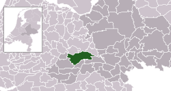 Location in Gelderland | |||
| Coordinates: 51°58′N 5°26′E / 51.967°N 5.433°E / 51.967; 5.433Coordinates: 51°58′N 5°26′E / 51.967°N 5.433°E / 51.967; 5.433 | |||
| Country | Netherlands | ||
| Province | Gelderland | ||
| Government [1] | |||
| • Body | Municipal council | ||
| • Mayor | Jan de Boer (D66) | ||
| Area [2] | |||
| • Total | 142.92 km2 (55.18 sq mi) | ||
| • Land | 134.26 km2 (51.84 sq mi) | ||
| • Water | 8.66 km2 (3.34 sq mi) | ||
| Elevation [3] | 5 m (16 ft) | ||
| Population (August 2017)[4] | |||
| • Total | 26,353 | ||
| • Density | 196/km2 (510/sq mi) | ||
| Time zone | UTC+1 (CET) | ||
| • Summer (DST) | UTC+2 (CEST) | ||
| Postcode | Parts of 4000 and 4100 ranges | ||
| Area code | 0344, 0345 | ||
| Website | www.buren.nl | ||


Dutch Topographic map of Buren, June 2015
Buren (![]() pronunciation (help·info)) is a town and municipality in the Betuwe region of the Netherlands. The name originated from the word the Dutch word “buren”, which means neighbour.
pronunciation (help·info)) is a town and municipality in the Betuwe region of the Netherlands. The name originated from the word the Dutch word “buren”, which means neighbour.
Contents
1 Geography
1.1 Population Centers
2 History
3 Historical Sites
4 Government and Politics
5 Demographics
6 Gallery
7 Twin town
8 See also
9 References
10 External links
Geography
Buren is located in Gelderland, a province of the Netherlands. It is part of the landscape of Betuwe, a very fertile strip of land between two branches of Rhine-Meuse Delta, the Nederrijn in the north and the Waal in the south.
Population Centers
Population centers include:
- Aalst
- Asch
- Beusichem
- Buren
- Eck en Wiel
- Erichem
- Ingen
- Kerk-Avezaath
- Lienden
- Ommeren
- Ravenswaaij
- Rijswijk
- Zoelen
- Zoelmond
History
The earliest known settlement of the region occurred as early as 772.[5] The castle was built by the Lords of Buren and was first mentioned in 1298. The town was granted city rights in 1395 by Sir Alard IV of Buren which led to the construction of a defensive wall and a moat, significant portions of which still stand. In 1492, the region was promoted to a county (i.e. a territory ruled by a count) but had limited economic influence due to its geographic isolation. By 1574, the previously Catholic parish church of Saint-Lambert (Dutch: Sint Lambertus) became Calvinist Reformed Protestant.[citation needed]
The Castle eventually came into the possession of the House of Orange, the royal family of the Netherlands. The Dutch royal family has been known to use the name van Buren as an alias to give themselves some degree of anonymity. William III of England obtained the title Buren. The Dutch royal family, still use this as a title. The Castle was gradually demolished between 1804 and 1883. The eighth president of the United States, Martin Van Buren, traced his ancestry to inhabitants of the city, who had taken the surname Van Buren after relocating to the Dutch colony of New Netherland in what is now the state of New York.[citation needed]
Historical Sites
Buren has two museums:
- The Museum of the Royal Military Police, located in a 17th-century orphanage.[6]
- The Museum of the Dutch Royal Family, located in the historic city hall.[7]
It is also home to De Prins Van Oranje, a restored windmill.
Government and Politics
The title "Count or Countess of Buren and Leerdam" is held by the Dutch monarchy due to Prince William of Orange's marriage to the Countess of Buren, Anna of Egmont, in 1551. As a result, the county and the town of Buren fall under the control of the Royal House of Orange-Nassau.
Demographics
Dutch: 92.9%
African: 0.7%
European: 4.7%
Arabian: 0.5%- Other: 1.2%[8]
Gallery

The Culemborg gate with the Saint-Lambertus church (Buren) in the background.

Statue in the center of Buren - William of Orange and Anna van Buren.

Strollers in Buren - Herenstraat and the Rodeheldenstraat in the background.
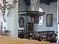
Pulpit of the Saint Lambertus church in Buren.

Weighing scales and village pump on the market square in Buren.

Buren, church (de Sint-Lambertuskerk) behind the wall

Buren, orphan house behind the wall
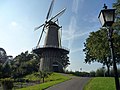
De Prins Van Oranje windmill


Twin town
 Kinderhook, New York, United States[9]
See also
- Van Buren (surname)
- House of Egmond
References
^ "Samenstelling college" [Members of the board] (in Dutch). Gemeente Buren. Archived from the original on 14 July 2014. Retrieved 18 June 2014..mw-parser-output cite.citation{font-style:inherit}.mw-parser-output .citation q{quotes:"""""""'""'"}.mw-parser-output .citation .cs1-lock-free a{background:url("//upload.wikimedia.org/wikipedia/commons/thumb/6/65/Lock-green.svg/9px-Lock-green.svg.png")no-repeat;background-position:right .1em center}.mw-parser-output .citation .cs1-lock-limited a,.mw-parser-output .citation .cs1-lock-registration a{background:url("//upload.wikimedia.org/wikipedia/commons/thumb/d/d6/Lock-gray-alt-2.svg/9px-Lock-gray-alt-2.svg.png")no-repeat;background-position:right .1em center}.mw-parser-output .citation .cs1-lock-subscription a{background:url("//upload.wikimedia.org/wikipedia/commons/thumb/a/aa/Lock-red-alt-2.svg/9px-Lock-red-alt-2.svg.png")no-repeat;background-position:right .1em center}.mw-parser-output .cs1-subscription,.mw-parser-output .cs1-registration{color:#555}.mw-parser-output .cs1-subscription span,.mw-parser-output .cs1-registration span{border-bottom:1px dotted;cursor:help}.mw-parser-output .cs1-ws-icon a{background:url("//upload.wikimedia.org/wikipedia/commons/thumb/4/4c/Wikisource-logo.svg/12px-Wikisource-logo.svg.png")no-repeat;background-position:right .1em center}.mw-parser-output code.cs1-code{color:inherit;background:inherit;border:inherit;padding:inherit}.mw-parser-output .cs1-hidden-error{display:none;font-size:100%}.mw-parser-output .cs1-visible-error{font-size:100%}.mw-parser-output .cs1-maint{display:none;color:#33aa33;margin-left:0.3em}.mw-parser-output .cs1-subscription,.mw-parser-output .cs1-registration,.mw-parser-output .cs1-format{font-size:95%}.mw-parser-output .cs1-kern-left,.mw-parser-output .cs1-kern-wl-left{padding-left:0.2em}.mw-parser-output .cs1-kern-right,.mw-parser-output .cs1-kern-wl-right{padding-right:0.2em}
^ "Kerncijfers wijken en buurten" [Key figures for neighbourhoods]. CBS Statline (in Dutch). CBS. 2 July 2013. Retrieved 12 March 2014.
^ "Postcodetool for 4021VZ". Actueel Hoogtebestand Nederland (in Dutch). Het Waterschapshuis. Retrieved 18 June 2014.
^ "Bevolkingsontwikkeling; regio per maand" [Population growth; regions per month]. CBS Statline (in Dutch). CBS. 27 October 2017. Retrieved 27 October 2017.
^ Stenvert, R. et al. (2000). Monumenten in Nederland: Gelderland, p. 124–127. Zwolle: Waanders Uitgevers.
ISBN 90-400-9406-3
^ "Home - Marechausseemuseum". Marechausseemuseum.nl. Retrieved 15 January 2017.
^ "Burenenoranje". burenenoranje.nl. Archived from the original on 18 February 2009. Retrieved 15 January 2017.
^ "Zorgatlas". www.zorgatlas.nl. Retrieved 15 January 2017.
^ "Kinderhook to honor sister city". Times Union. Albany, N.Y.: Hearst Newspapers. July 21, 2018. Retrieved August 5, 2018.
External links
- Official website
Places adjacent to Buren | ||||||||||
|---|---|---|---|---|---|---|---|---|---|---|
| ||||||||||
Municipalities of Gelderland | ||
|---|---|---|
|  | |
| ||


