Middletown, Delaware
Middletown, Delaware | ||
|---|---|---|
Town | ||
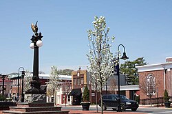 Four corners at the main intersection of Middletown | ||
| ||
| Nickname(s): Diamond Town of the Diamond State | ||
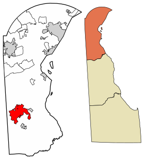 Location of Middletown in New Castle County, Delaware. | ||
 Middletown Location within the state of Delaware Show map of Delaware  Middletown Middletown (the US) Show map of the US | ||
| Coordinates: 39°26′58″N 75°42′59″W / 39.44944°N 75.71639°W / 39.44944; -75.71639Coordinates: 39°26′58″N 75°42′59″W / 39.44944°N 75.71639°W / 39.44944; -75.71639 | ||
| Country | ||
| State | ||
| County | ||
| Incorporated | 1861 | |
| Government | ||
| • Mayor | Ken Branner | |
| • Vice Mayor | Jim Reynolds | |
| Area [1] | ||
| • Total | 11.83 sq mi (30.64 km2) | |
| • Land | 11.77 sq mi (30.48 km2) | |
| • Water | 0.06 sq mi (0.16 km2) | |
| Elevation | 66 ft (20 m) | |
| Population (2010) | ||
| • Total | 18,871 | |
| • Estimate (2016)[2] | 20,876 | |
| • Density | 1,773.96/sq mi (684.93/km2) | |
| Time zone | UTC−5 (Eastern (EST)) | |
| • Summer (DST) | UTC−4 (EDT) | |
| ZIP code | 19709 | |
| Area code(s) | 302 | |
| FIPS code | 10-47030 | |
GNIS feature ID | 214304[3] | |
| Website | www.middletownde.org | |

Middletown is a town in New Castle County, Delaware, United States. According to the 2010 Census, the population of the town is 18,871.[4]
Contents
1 Geography
2 Demographics
3 Growth
4 Infrastructure
4.1 Transportation
4.2 Utilities
4.3 Health care
5 Education
6 Events
7 Media
8 Film appearances
9 Notable people
10 References
11 External links
Geography
Middletown is located at 39°26′58″N 75°42′59″W / 39.44944°N 75.71639°W / 39.44944; -75.71639 (39.4495560, -75.7163207)[5] with an elevation of 66 feet (20.1 m).[6]
According to the United States Census Bureau, the town has a total area of 11.61 square miles (30.1 km2), of which, 11.61 square miles (30.1 km2) is land and 0.16% is water.
Demographics
As of the census[7] of 2000, there were 6,161 people, 2,298 households, and 1,631 families residing in the town. The population density was 962.4 people per square mile (371.7/km²). There were 2,514 housing units at an average density of 392.7 per square mile (151.7/km²). The racial makeup of the town was 94.42% White, 1.30% African American, 0.11% Native American, 0.78% Asian, 0.02% Pacific Islander, 1.93% from other races, and 1.44% from two or more races. Hispanic or Latino of any race were 5.29% of the population.
Population in 2012: 19,483
White alone - 10,804 (58.4%)
Black alone - 4,863 (26.3%)
Hispanic - 1,319 (7.1%)
Asian alone - 940 (5.1%)
Two or more races - 491 (2.7%)
American Indian alone - 29 (0.2%)
Other race alone - 31 (0.2%)
•Native Hawaiian and Other Pacific Islander alone - 18 (0.10%)[8]
There were 2,298 households out of which 41.3% had children under the age of 18 living with them, 48.5% were married couples living together, 18.1% had a female householder with no husband present, and 29.0% were non-families. 22.9% of all households were made up of individuals and 8.5% had someone living alone who was 65 years of age or older. The average household size was 2.68 and the average family size was 3.14.
In the town, the population was spread out with 30.9% under the age of 18, 9.5% from 18 to 24, 33.5% from 25 to 44, 18.3% from 45 to 64, and 7.9% who were 65 years of age or older. The median age was 31 years. For every 100 females, there were 90.7 males. For every 100 females age 18 and over, there were 85.7 males.
The median income for a household in the town was $41,663, and the median income for a family was $47,270. Males had a median income of $35,688 versus $30,044 for females. The per capita income for the town was $18,517. About 8.8% of families and 10.9% of the population were below the poverty line, including 12.7% of those under age 18 and 13.6% of those age 65 or over.
Growth
Recent annexations of land have stimulated Middletown's growth: it is known as the fastest growing area in Delaware. Between 2000 and 2010, the population of the town grew 206.3%.[6] Many affluent housing developments surround the town's center, especially to its north, attracting, among others, commuters from Wilmington, and even Philadelphia.
Middletown's commerce has grown accordingly. National retail and food chain stores have opened locations in the area, with significant growth along the U.S. 301 corridor. An Amazon fulfillment center is located in Middletown. This growth is more characteristic of suburban sprawl, a stark difference from Middletown's historic growth patterns.
As a result of the rapid growth of the area, Middletown established its own police force, The Middletown Police Department, on July 2, 2007. The Police Department officially began on October 3, 2007 with a foundation of 20 officers from surrounding Delaware police departments.
Infrastructure
Transportation
Limited-access highway Delaware Route 1 is east of Middletown, and the town has a signed exit at Odessa for Delaware Route 299. Delaware 299 also serves as Middletown's Main Street. U.S. Route 301 is just west of Middletown, serving the Chesapeake Bay Bridge to the southwest and the Summit Bridge to the north. Delaware Route 15, a rural road, is concurrent with U.S. 301 at Middletown, allowing access to Dover and Smyrna. Delaware Route 71 heads south from Middletown to Townsend and U.S. Route 13.
DART First State serves Middletown along the Route 43 bus, which connects to a park and ride in Odessa. From here, riders have access to the Route 45 bus to Wilmington, the Route 301 bus to Wilmington and Dover, and the seasonal Route 305 "Beach Connection" bus to Lewes and Rehoboth Beach. The Route 47 bus provides rush hour and Saturday service between the Amazon fulfillment center in Middletown and Wilmington. The Route 302 bus provides intercounty service between Newark and Dover via Middletown, serving the Amazon fulfillment center.[9]
A railroad operated by the Delmarva Central Railroad runs through the center of Middletown.[10]
Summit Airport is just to the north of the town. The larger Wilmington Airport is in New Castle, and the nearest airport with commercial air service is the Philadelphia International Airport in Philadelphia, Pennsylvania.
Utilities
The Town of Middletown Electric Department provides electricity to the town.[11] The electric department is a member of the Delaware Municipal Electric Corporation.[12] The town maintains an electric substation, with electricity supplied to the substation by a 138,000 kV line from Delmarva Power's Mt. Pleasant Substation. A second 138,000 kV line to the town's substation is being constructed from Delmarva Power's Townsend Substation to increase the reliability of electricity in Middletown.[13] The Water/Wasterwater Department provides water and sewer service to Middletown.[11] Trash Tech provides trash collection and recycling to Middletown.[14] Natural gas service in Middletown is provided by Chesapeake Utilities.[15]
Health care
Christiana Care Health System operates the Middletown Free-standing Emergency Department in Middletown, offering 24-hour emergency care with 18 treatment rooms.[16] It opened in April 2013 at a cost of $34 million.[17]
Education
| Historical population | |||
|---|---|---|---|
| Census | Pop. | %± | |
| 1850 | 368 | — | |
| 1860 | 523 | 42.1% | |
| 1870 | 915 | 75.0% | |
| 1880 | 1,280 | 39.9% | |
| 1890 | 1,454 | 13.6% | |
| 1900 | 1,567 | 7.8% | |
| 1910 | 1,399 | −10.7% | |
| 1920 | 1,260 | −9.9% | |
| 1930 | 1,247 | −1.0% | |
| 1940 | 1,529 | 22.6% | |
| 1950 | 1,755 | 14.8% | |
| 1960 | 2,191 | 24.8% | |
| 1970 | 2,644 | 20.7% | |
| 1980 | 2,946 | 11.4% | |
| 1990 | 3,834 | 30.1% | |
| 2000 | 6,161 | 60.7% | |
| 2010 | 18,871 | 206.3% | |
| Est. 2016 | 20,876 | [2] | 10.6% |
| U.S. Decennial Census[18] | |||
Public education in Middletown is provided by the Appoquinimink School District, which has recently built a new elementary school to accommodate the population growth of the area and overcrowding at the other elementary schools. Overcrowding at Middletown High School, which was over-capacity by 400 students during the 2005-2006 school year, resulted in the construction of a second high school, Appoquinimink High School, which opened in Fall 2008.[19]
The St. Georges Technical High School is located to the northeast of town.
Three private schools are located on the side of the town: MOT Charter School and St. Anne's Episcopal School, with the former being K-12 and the latter K-8, and St. Andrew's School, a coed boarding school affiliated with the Episcopal Diocese of Delaware.
Wilmington University has a location in town.
Events
Middletown is home to the Olde Tyme Peach Festival, an annual tradition that attracts tens of thousands of visitors each August. Main Street in the center of town is closed to traffic and activities begin with a parade down the street. Other entertainment includes local art and historical exhibits, live music, crafts, games, and a variety of food including limited time peach flavored treats. There is also a 5k run/walk on the same day of the festival, where all proceeds are donated to benefit the local sports boosters.
Middletown hosts the M.O.T. Big Ball Marathon, an annual Labor Day event that benefits local charities. The marathon runs 24 hours straight where people of all ages come out to play baseball on previously registered teams with an oversized softball, giving it the name "Big Ball". In 2013 the marathon had its most successful year, raising a record $65,000 in funds over the 24 hours.
Middletown also hosts an annual Hummers parade. The parade's name is a spoof of the nearby Philadelphia Mummers parade. As opposed to the Mummers, which is judged seriously, the Hummers dress up and make fun of all the popular news headlines, political, celebrity, and local happenings of the year.
Media
The Middletown Transcript is the main publication for the Middletown, Odessa and Townsend area. The first edition was printed on Jan. 4, 1868. This community newspaper is published every Thursday.
Film appearances
The 1989 film Dead Poets Society starring Robin Williams was filmed almost entirely on the school grounds at St. Andrew's School. The theatre scene was filmed at The Everett Theatre on Main Street.
The episode of The West Wing entitled "Two Cathedrals" (#44) was partly filmed at St. Andrew's School.
Notable people
Dennis C. Blair, former Director of National Intelligence and retired United States Navy Admiral, attended St. Andrew's School
Erin Burnett, journalist, attended St. Andrew's School
Chris Godwin, football player
Stephanie Hansen, Delaware state senator
Dwayne Henry, former Major League Baseball pitcher
Chad Kuhl, Major League Baseball pitcher Pittsburgh Pirates
Morgan Hurd, gymnast
Reggie Leach, former Philadelphia Flyers forward
Shane O'Neill, winner of the first season of Ink Master.
Maggie Rogers (singer), attended St. Andrew's School
Silas Simmons, longest-lived professional baseball player in history
Tom Verlaine, guitarist and singer for art punk group Television, attended St. Andrew's School
Loudon Wainwright III, folk singer, attended St. Andrew's School
References
^ "2016 U.S. Gazetteer Files". United States Census Bureau. Retrieved Jul 25, 2017..mw-parser-output cite.citation{font-style:inherit}.mw-parser-output q{quotes:"""""""'""'"}.mw-parser-output code.cs1-code{color:inherit;background:inherit;border:inherit;padding:inherit}.mw-parser-output .cs1-lock-free a{background:url("//upload.wikimedia.org/wikipedia/commons/thumb/6/65/Lock-green.svg/9px-Lock-green.svg.png")no-repeat;background-position:right .1em center}.mw-parser-output .cs1-lock-limited a,.mw-parser-output .cs1-lock-registration a{background:url("//upload.wikimedia.org/wikipedia/commons/thumb/d/d6/Lock-gray-alt-2.svg/9px-Lock-gray-alt-2.svg.png")no-repeat;background-position:right .1em center}.mw-parser-output .cs1-lock-subscription a{background:url("//upload.wikimedia.org/wikipedia/commons/thumb/a/aa/Lock-red-alt-2.svg/9px-Lock-red-alt-2.svg.png")no-repeat;background-position:right .1em center}.mw-parser-output .cs1-subscription,.mw-parser-output .cs1-registration{color:#555}.mw-parser-output .cs1-subscription span,.mw-parser-output .cs1-registration span{border-bottom:1px dotted;cursor:help}.mw-parser-output .cs1-hidden-error{display:none;font-size:100%}.mw-parser-output .cs1-visible-error{font-size:100%}.mw-parser-output .cs1-subscription,.mw-parser-output .cs1-registration,.mw-parser-output .cs1-format{font-size:95%}.mw-parser-output .cs1-kern-left,.mw-parser-output .cs1-kern-wl-left{padding-left:0.2em}.mw-parser-output .cs1-kern-right,.mw-parser-output .cs1-kern-wl-right{padding-right:0.2em}
^ ab "Population and Housing Unit Estimates". Retrieved June 9, 2017.
^ "Middletown". Geographic Names Information System. United States Geological Survey.
^ "The Delaware Census State Data Center". Archived from the original on 31 December 2016. Retrieved 21 December 2016.
^ "U.S. Gazetteer files: 2010, 2000, and 1990". United States Census Bureau. 2011-02-12. Retrieved 2011-04-23.
^ ab "Middletown, Delaware". Geographic Names Information System. United States Geological Survey. Retrieved 2007-08-02.
^ "American FactFinder". United States Census Bureau. Retrieved 2008-01-31.
^ "Middletown, Delaware (DE 19709, 19734) profile: population, maps, real estate, averages, homes, statistics, relocation, travel, jobs, hospitals, schools, crime, moving, houses, news, sex offenders". Retrieved 21 December 2016.
^ "Routes and Schedules". DART First State. Retrieved 2013-08-16.
^ "Delmarva Central Railroad". Carload Express. Retrieved March 27, 2017.
^ ab "Public Works". Town of Middletown Delaware. Retrieved August 13, 2017.
^ "Members". Delaware Municipal Electric Corporation. Retrieved August 14, 2017.
^ Smith, Jerry (December 18, 2017). "Backup electrical transmission line signs Middletown is still growing". The News Journal. Wilmington, DE. Retrieved March 15, 2018.
^ "Info Page for Middletown, DE". Trash Tech. Retrieved August 13, 2017.
^ "Delmarva Service Territory". Chesapeake Utilities. Retrieved August 14, 2017.
^ "Middletown Free-standing Emergency Department". Christiana Care Health System. Retrieved June 21, 2014.
^ Goss, Scott (April 10, 2013). "Christiana Care's Middletown Emergency Department to open next week". Middletown Transcript. Retrieved June 21, 2014.
^ "Census of Population and Housing". Census.gov. Retrieved June 4, 2015.
^ "Our Schools: Appoquinimink High". Appoquinimink School District. Retrieved March 30, 2011.
[permanent dead link]
External links
- Town of Middletown
Municipalities and communities of New Castle County, Delaware, United States | ||
|---|---|---|
County seat: Wilmington | ||
| Cities |
|  |
| Towns |
| |
| Villages |
| |
| CDPs |
| |
| Unincorporated communities |
| |
| Hundreds |
| |
| Ghost towns |
| |
| Footnotes | ‡This populated place also has portions in an adjacent county or counties | |


